Puquina geodata
Puquina (Moquegua) is a seat of a third-order administrative division; located in Peru in America/Lima (GMT-5) time zone. In our database, there are 305 cities with bigger population. Compared to other cities in Peru, 96.3% of cities are located further ↑North; 89% of cities are located further ←West and 57.7% of cities have lower elevation than Puquina. Note1
Administrative division(s):
- Level 1: Moquegua
- Level 2: Provincia de General Sánchez Cerro
- Level 3: Puquina


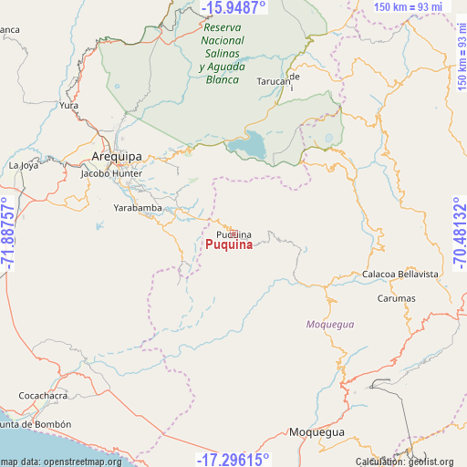
Puquina GPS coordinates[2]
16° 37' 24.996" South, 71° 11' 3.984" West
| Map corner | latitude | longitude |
|---|---|---|
| Upper-left | -15.9487°, | -71.88757° |
| Center: | -16.62361°, | -71.18444° |
| Lower-right: | -17.29615°, | -70.48132° |
| Map W x H: | 149.8×149.8 km | = 93.1×93.1mi |
| max Lat: | -0.96667° ⇑96.3% North |
| Puquina: | -16.62361° |
| min Lat: | ⇓3.7% South -18.01465° |
| min Long | Puquina | max Long |
| -81.30472° | -71.18444° | -69.04167° |
| W 89%⇐ | ⇒11% E |
Elevation
Elevation of Puquina is 3098 m = 10164 ft, and this is 779.3 m = 2557 ft above average elevation for this country.
| Max E: |
5022 m = 16476 ft | 42.3% |
| Puquina | 3098 m 10164 ft | |
| Avg. | 2318.7 m = 7607 ft | |
Min E: |
1 m = 3 ft | 57.7% |
See also: Peru elevation on elevation.city.
Geographical zone
Puquina is located in South Torrid zone (between Equator and Tropic of Capricorn). Distance of this Southern Tropic circle is 757.5 km =470.7 mi to South.| Distance of | km | miles | from Puquina |
|---|---|---|---|
| Equator | 1848.4 | 1148.5 | to North |
| Tropic Capricorn | 757.5 | 470.7 | to South |
| Antarctic Circle | 5552.8 | 3450.3 | to South |
| South Pole | 8158.7 | 5069.6 | to South |


Nearby cities:
15 places around Puquina: (largest is in red/bold)
• Arequipa
45 km =28 mi,  303°
303°
• Characato
36.3 km =22.6 mi, 298°
• Chiguata
33.9 km =21.1 mi,  317°
317°
• Coalaque
17.6 km =10.9 mi,  99°
99°
• La Capilla
14.8 km =9.2 mi,  177°
177°
• Matalaque
42.2 km =26.2 mi,  68°
68°
• Omate
22.4 km =13.9 mi,  107°
107°
• Pocsi
24.8 km =15.4 mi, 298°
• Quequeña
29.3 km =18.2 mi,  284°
284°
• Quinistaquillas
35 km =21.7 mi, 113°
• Sabandia
37.9 km =23.5 mi, 297°
• Socabaya
40.4 km =25.1 mi,  294°
294°
• Tiabaya
47.3 km =29.4 mi, 294°
• Ubinas
42 km =26.1 mi,  53°
53°
• Yarabamba
32.3 km =20.1 mi, 285°
Sources, notices
• [Note1] Compared only with cities in Peru existing in our database
• [Src1] Map data: © OpenStreetMap contributors (CC-BY-SA)
• [Src2] Other city data from geonames.org with taken over terms of usage.
• [Src3] Geographical zone / Annual Mean Temperature by Robert A. Rohde @ Wikipedia
