La Capilla geodata
La Capilla (Moquegua) is a seat of a third-order administrative division; located in Peru in America/Lima (GMT-5) time zone. In our database, there are 305 cities with bigger population. Compared to other cities in Peru, 97.1% of cities are located further ↑North; 89.1% of cities are located further ←West and 67.3% of cities have higher elevation than La Capilla. Note1
Administrative division(s):
- Level 1: Moquegua
- Level 2: Provincia de General Sánchez Cerro
- Level 3: La Capilla


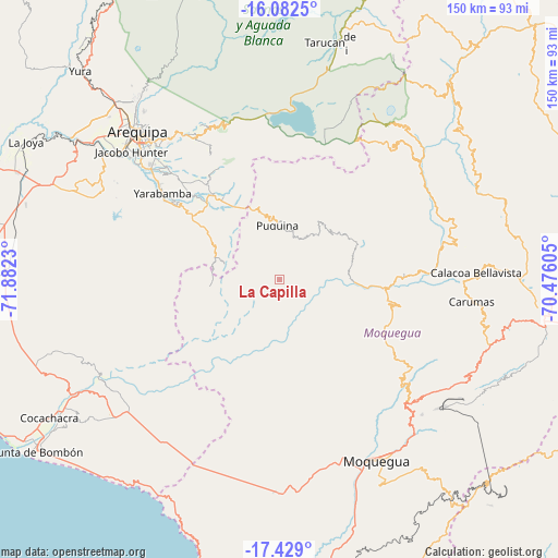
La Capilla GPS coordinates[2]
16° 45' 24.984" South, 71° 10' 45.012" West
| Map corner | latitude | longitude |
|---|---|---|
| Upper-left | -16.0825°, | -71.8823° |
| Center: | -16.75694°, | -71.17917° |
| Lower-right: | -17.429°, | -70.47605° |
| Map W x H: | 149.7×149.7 km | = 93×93mi |
| max Lat: | -0.96667° ⇑97.1% North |
| La Capilla: | -16.75694° |
| min Lat: | ⇓2.9% South -18.01465° |
| min Long | La Capilla | max Long |
| -81.30472° | -71.17917° | -69.04167° |
| W 89.1%⇐ | ⇒10.9% E |
Elevation
Elevation of La Capilla is 1842 m = 6043 ft, and this is 476.7 m = 1564 ft below average elevation for this country.
| Max E: |
5022 m = 16476 ft | 67.3% |
| Avg. | 2318.7 m = 7607 ft | |
| La Capilla | 1842 m = 6043 ft | |
Min E: |
1 m = 3 ft | 32.7% |
See also: Peru elevation on elevation.city.
Geographical zone
La Capilla is located in South Torrid zone (between Equator and Tropic of Capricorn). Distance of this Southern Tropic circle is 742.7 km =461.5 mi to South.| Distance of | km | miles | from La Capilla |
|---|---|---|---|
| Equator | 1863.2 | 1157.7 | to North |
| Tropic Capricorn | 742.7 | 461.5 | to South |
| Antarctic Circle | 5538 | 3441.2 | to South |
| South Pole | 8143.9 | 5060.4 | to South |


Nearby cities:
15 places around La Capilla: (largest is in red/bold)
• Calacoa
51 km =31.7 mi,  89°
89°
• Carumas
49.7 km =30.9 mi,  97°
97°
• Characato
45.7 km =28.4 mi,  314°
314°
• Chiguata
46.1 km =28.6 mi,  329°
329°
• Coalaque
20.5 km =12.7 mi,  54°
54°
• Matalaque
49.2 km =30.6 mi, 51°
• Omate
22.4 km =13.9 mi,  68°
68°
• Pocsi
34.8 km =21.6 mi,  320°
320°
• Puquina
14.8 km =9.2 mi,  357°
357°
• Quequeña
36.5 km =22.7 mi, 307°
• Quinistaquillas
31.5 km =19.6 mi, 88°
• Sabandia
47 km =29.2 mi, 313°
• Socabaya
48.9 km =30.4 mi, 310°
• Torata
50.4 km =31.3 mi,  134°
134°
• Yarabamba
39.3 km =24.4 mi, 306°
Sources, notices
• [Note1] Compared only with cities in Peru existing in our database
• [Src1] Map data: © OpenStreetMap contributors (CC-BY-SA)
• [Src2] Other city data from geonames.org with taken over terms of usage.
• [Src3] Geographical zone / Annual Mean Temperature by Robert A. Rohde @ Wikipedia
