Tiabaya geodata
Tiabaya (Arequipa) is a seat of a third-order administrative division; located in Peru in America/Lima (GMT-5) time zone. In our database, there are 305 cities with bigger population. Compared to other cities in Peru, 95.4% of cities are located further ↑North; 84.5% of cities are located further ←West and 63.6% of cities have higher elevation than Tiabaya. Note1


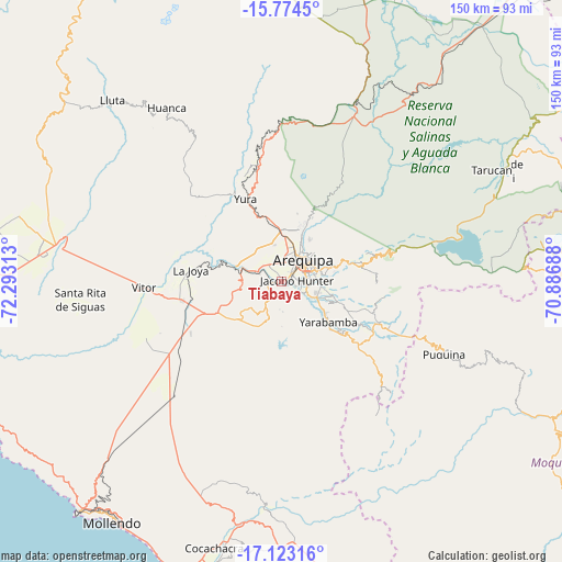
Tiabaya GPS coordinates[2]
16° 27' 0" South, 71° 35' 24" West
| Map corner | latitude | longitude |
|---|---|---|
| Upper-left | -15.7745°, | -72.29313° |
| Center: | -16.45°, | -71.59° |
| Lower-right: | -17.12316°, | -70.88688° |
| Map W x H: | 150×150 km | = 93.2×93.2mi |
| max Lat: | -0.96667° ⇑95.4% North |
| Tiabaya: | -16.45° |
| min Lat: | ⇓4.6% South -18.01465° |
| min Long | Tiabaya | max Long |
| -81.30472° | -71.59° | -69.04167° |
| W 84.5%⇐ | ⇒15.5% E |
Elevation
Elevation of Tiabaya is 2176 m = 7139 ft, and this is 142.7 m = 468 ft below average elevation for this country.
| Max E: |
5022 m = 16476 ft | 63.6% |
| Avg. | 2318.7 m = 7607 ft | |
| Tiabaya | 2176 m = 7139 ft | |
Min E: |
1 m = 3 ft | 36.4% |
See also: Peru elevation on elevation.city.
Geographical zone
Tiabaya is located in South Torrid zone (between Equator and Tropic of Capricorn). Distance of this Southern Tropic circle is 776.9 km =482.7 mi to South.| Distance of | km | miles | from Tiabaya |
|---|---|---|---|
| Equator | 1829.1 | 1136.5 | to North |
| Tropic Capricorn | 776.9 | 482.7 | to South |
| Antarctic Circle | 5572.1 | 3462.3 | to South |
| South Pole | 8178 | 5081.6 | to South |


Nearby cities:
15 places around Tiabaya: (largest is in red/bold)
• Arequipa
8.2 km =5.1 mi,  45°
45°
• Characato
11.5 km =7.1 mi,  99°
99°
• Chiguata
21 km =13 mi,  74°
74°
• Coalaque
64.6 km =40.1 mi,  110°
110°
• La Capilla
55.5 km =34.5 mi,  127°
127°
• Pocsi
22.7 km =14.1 mi, 108°
• Pucara
54.1 km =33.6 mi,  14°
14°
• Puquina
47.3 km =29.4 mi, 114°
• Quequeña
19 km =11.8 mi, 128°
• Sabandia
9.8 km =6.1 mi, 100°
• Socabaya
7 km =4.3 mi, 108°
• Tarucani
63.2 km =39.3 mi,  62°
62°
• Uchumayo
9.2 km =5.7 mi,  287°
287°
• Yarabamba
16.2 km =10.1 mi, 131°
• Yura
24 km =14.9 mi,  336°
336°
Sources, notices
• [Note1] Compared only with cities in Peru existing in our database
• [Src1] Map data: © OpenStreetMap contributors (CC-BY-SA)
• [Src2] Other city data from geonames.org with taken over terms of usage.
• [Src3] Geographical zone / Annual Mean Temperature by Robert A. Rohde @ Wikipedia
