Pocohuanca geodata
Pocohuanca (Apurímac) is a seat of a third-order administrative division; located in Peru in America/Lima (GMT-5) time zone. In our database, there are 305 cities with bigger population. Compared to other cities in Peru, 78.6% of cities are located further ↑North; 73.1% of cities are located further ←West and 64.9% of cities have lower elevation than Pocohuanca. Note1


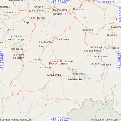
Pocohuanca GPS coordinates[2]
14° 13' 0.012" South, 73° 4' 59.988" West
| Map corner | latitude | longitude |
|---|---|---|
| Upper-left | -13.53407°, | -73.78646° |
| Center: | -14.21667°, | -73.08333° |
| Lower-right: | -14.89722°, | -72.38021° |
| Map W x H: | 151.6×151.6 km | = 94.2×94.2mi |
| max Lat: | -0.96667° ⇑78.6% North |
| Pocohuanca: | -14.21667° |
| min Lat: | ⇓21.4% South -18.01465° |
| min Long | Pocohuanca | max Long |
| -81.30472° | -73.08333° | -69.04167° |
| W 73.1%⇐ | ⇒26.9% E |
Elevation
Elevation of Pocohuanca is 3258 m = 10689 ft, and this is 939.3 m = 3082 ft above average elevation for this country.
| Max E: |
5022 m = 16476 ft | 35.1% |
| Pocohuanca | 3258 m 10689 ft | |
| Avg. | 2318.7 m = 7607 ft | |
Min E: |
1 m = 3 ft | 64.9% |
See also: Peru elevation on elevation.city.
Geographical zone
Pocohuanca is located in South Torrid zone (between Equator and Tropic of Capricorn). Distance of this Southern Tropic circle is 1025.2 km =637 mi to South.| Distance of | km | miles | from Pocohuanca |
|---|---|---|---|
| Equator | 1580.7 | 982.2 | to North |
| Tropic Capricorn | 1025.2 | 637 | to South |
| Antarctic Circle | 5820.4 | 3616.6 | to South |
| South Pole | 8426.3 | 5235.9 | to South |


Nearby cities:
15 places around Pocohuanca: (largest is in red/bold)
• Antabamba
27.5 km =17.1 mi,  125°
125°
• Ayahuay
2.1 km =1.3 mi,  61°
61°
• Capaya
27.5 km =17.1 mi,  293°
293°
• Caraybamba
19.7 km =12.2 mi,  205°
205°
• Chalhuanca
18.4 km =11.4 mi,  239°
239°
• Chapimarca
26.9 km =16.7 mi,  4°
4°
• Cotaruse
25.9 km =16.1 mi, 211°
• Huaquirca
24.4 km =15.2 mi,  121°
121°
• Huayllo
22.1 km =13.7 mi,  295°
295°
• Pachaconas
6.3 km =3.9 mi,  95°
95°
• Sabaino
17.9 km =11.1 mi, 124°
• Sañayca
27.2 km =16.9 mi,  272°
272°
• Soraya
25.4 km =15.8 mi,  283°
283°
• Tapairihua
10.6 km =6.6 mi,  322°
322°
• Yanaca
6.2 km =3.9 mi, 268°
Sources, notices
• [Note1] Compared only with cities in Peru existing in our database
• [Src1] Map data: © OpenStreetMap contributors (CC-BY-SA)
• [Src2] Other city data from geonames.org with taken over terms of usage.
• [Src3] Geographical zone / Annual Mean Temperature by Robert A. Rohde @ Wikipedia
