Chalhuanca geodata
Chalhuanca (Apurímac) is a seat of a third-order administrative division; located in Peru in America/Lima (GMT-5) time zone. In our database, there are 305 cities with bigger population. Compared to other cities in Peru, 80.1% of cities are located further ↑North; 71.9% of cities are located further ←West and 54.1% of cities have lower elevation than Chalhuanca. Note1


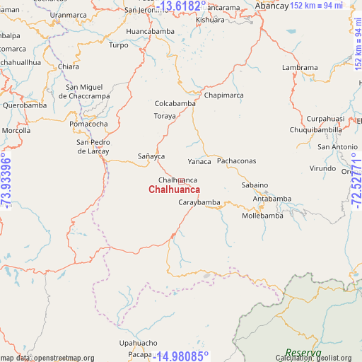
Chalhuanca GPS coordinates[2]
14° 18' 2.016" South, 73° 13' 50.988" West
| Map corner | latitude | longitude |
|---|---|---|
| Upper-left | -13.6182°, | -73.93396° |
| Center: | -14.30056°, | -73.23083° |
| Lower-right: | -14.98085°, | -72.52771° |
| Map W x H: | 151.5×151.5 km | = 94.1×94.1mi |
| max Lat: | -0.96667° ⇑80.1% North |
| Chalhuanca: | -14.30056° |
| min Lat: | ⇓19.9% South -18.01465° |
| min Long | Chalhuanca | max Long |
| -81.30472° | -73.23083° | -69.04167° |
| W 71.9%⇐ | ⇒28.1% E |
Elevation
Elevation of Chalhuanca is 3004 m = 9856 ft, and this is 685.3 m = 2248 ft above average elevation for this country.
| Max E: |
5022 m = 16476 ft | 45.9% |
| Chalhuanca | 3004 m 9856 ft | |
| Avg. | 2318.7 m = 7607 ft | |
Min E: |
1 m = 3 ft | 54.1% |
See also: Peru elevation on elevation.city.
Geographical zone
Chalhuanca is located in South Torrid zone (between Equator and Tropic of Capricorn). Distance of this Southern Tropic circle is 1015.8 km =631.2 mi to South.| Distance of | km | miles | from Chalhuanca |
|---|---|---|---|
| Equator | 1590.1 | 988 | to North |
| Tropic Capricorn | 1015.8 | 631.2 | to South |
| Antarctic Circle | 5811.1 | 3610.8 | to South |
| South Pole | 8417 | 5230.1 | to South |


Nearby cities:
15 places around Chalhuanca: (largest is in red/bold)
• Ayahuay
20.5 km =12.7 mi,  59°
59°
• Capaya
22.2 km =13.8 mi,  334°
334°
• Caraybamba
11.3 km =7 mi,  138°
138°
• Colcabamba
32.6 km =20.3 mi,  356°
356°
• Cotaruse
13.1 km =8.1 mi,  169°
169°
• Huayllo
19.1 km =11.9 mi,  347°
347°
• Pachaconas
23.8 km =14.8 mi,  68°
68°
• Pampachiri
36 km =22.4 mi,  290°
290°
• Pocohuanca
18.4 km =11.4 mi, 59°
• Sabaino
30.6 km =19 mi,  91°
91°
• Sañayca
15.4 km =9.6 mi,  312°
312°
• Soraya
17.7 km =11 mi, 330°
• Tapairihua
20.2 km =12.6 mi,  28°
28°
• Toraya
28.7 km =17.8 mi, 345°
• Yanaca
13.3 km =8.3 mi,  46°
46°
Sources, notices
• [Note1] Compared only with cities in Peru existing in our database
• [Src1] Map data: © OpenStreetMap contributors (CC-BY-SA)
• [Src2] Other city data from geonames.org with taken over terms of usage.
• [Src3] Geographical zone / Annual Mean Temperature by Robert A. Rohde @ Wikipedia
