Paratia geodata
Paratia (Puno) is a seat of a third-order administrative division; located in Peru in America/Lima (GMT-5) time zone. In our database, there are 305 cities with bigger population. Compared to other cities in Peru, 89.1% of cities are located further ↑North; 92.1% of cities are located further ←West and 98.7% of cities have lower elevation than Paratia. Note1


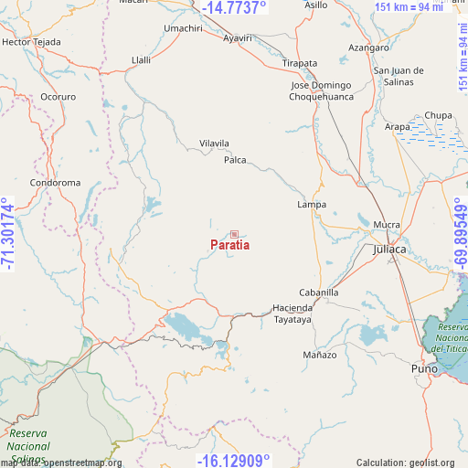
Paratia GPS coordinates[2]
15° 27' 9" South, 70° 35' 54.996" West
| Map corner | latitude | longitude |
|---|---|---|
| Upper-left | -14.7737°, | -71.30174° |
| Center: | -15.4525°, | -70.59861° |
| Lower-right: | -16.12909°, | -69.89549° |
| Map W x H: | 150.7×150.7 km | = 93.6×93.6mi |
| max Lat: | -0.96667° ⇑89.1% North |
| Paratia: | -15.4525° |
| min Lat: | ⇓10.9% South -18.01465° |
| min Long | Paratia | max Long |
| -81.30472° | -70.59861° | -69.04167° |
| W 92.1%⇐ | ⇒7.9% E |
Elevation
Elevation of Paratia is 4363 m = 14314 ft, and this is 2044.3 m = 6707 ft above average elevation for this country.
| Max E: |
5022 m = 16476 ft | 1.3% |
| Paratia | 4363 m 14314 ft | |
| Avg. | 2318.7 m = 7607 ft | |
Min E: |
1 m = 3 ft | 98.7% |
See also: Peru elevation on elevation.city.
Geographical zone
Paratia is located in South Torrid zone (between Equator and Tropic of Capricorn). Distance of this Southern Tropic circle is 887.8 km =551.7 mi to South.| Distance of | km | miles | from Paratia |
|---|---|---|---|
| Equator | 1718.2 | 1067.6 | to North |
| Tropic Capricorn | 887.8 | 551.7 | to South |
| Antarctic Circle | 5683 | 3531.3 | to South |
| South Pole | 8288.9 | 5150.5 | to South |


Nearby cities:
15 places around Paratia: (largest is in red/bold)
• Achaya
52.3 km =32.5 mi,  66°
66°
• Cabana
37.3 km =23.2 mi,  126°
126°
• Cabanilla
32.3 km =20.1 mi,  124°
124°
• Calapuja
43.6 km =27.1 mi, 69°
• Hacienda Huancane
51.4 km =31.9 mi,  216°
216°
• Huarichancara
53.7 km =33.4 mi,  247°
247°
• Juliaca
50.1 km =31.1 mi,  96°
96°
• Lampa
27.4 km =17 mi, 65°
• Mañazo
48 km =29.8 mi,  143°
143°
• Nicasio
44.6 km =27.7 mi,  56°
56°
• Ocuviri
50.4 km =31.3 mi,  318°
318°
• Palca
24.3 km =15.1 mi,  0°
0°
• Santa Lucía
27.3 km =17 mi,  181°
181°
• Vilavila
30.3 km =18.8 mi,  347°
347°
• Vilque
51.1 km =31.8 mi, 133°
Sources, notices
• [Note1] Compared only with cities in Peru existing in our database
• [Src1] Map data: © OpenStreetMap contributors (CC-BY-SA)
• [Src2] Other city data from geonames.org with taken over terms of usage.
• [Src3] Geographical zone / Annual Mean Temperature by Robert A. Rohde @ Wikipedia
