Santa Lucía geodata
Santa Lucía (Puno) is a populated place; located in Peru in America/Lima (GMT-5) time zone. With population of 4,320 people, there are 257 cities with bigger population in this country. Compared to other cities in Peru, 91.8% of cities are located further ↑North; 92% of cities are located further ←West and 95.3% of cities have lower elevation than Santa Lucía. Note1


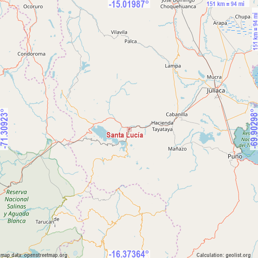
Santa Lucía GPS coordinates[2]
15° 41' 52.368" South, 70° 36' 21.96" West
| Map corner | latitude | longitude |
|---|---|---|
| Upper-left | -15.01987°, | -71.30923° |
| Center: | -15.69788°, | -70.6061° |
| Lower-right: | -16.37364°, | -69.90298° |
| Map W x H: | 150.5×150.5 km | = 93.5×93.5mi |
| max Lat: | -0.96667° ⇑91.8% North |
| Santa Lucía: | -15.69788° |
| min Lat: | ⇓8.2% South -18.01465° |
| min Long | Santa Lucía | max Long |
| -81.30472° | -70.6061° | -69.04167° |
| W 92%⇐ | ⇒8% E |
Elevation
Elevation of Santa Lucía is 4046 m = 13274 ft, and this is 1727.3 m = 5667 ft above average elevation for this country.
| Max E: |
5022 m = 16476 ft | 4.7% |
| Santa Lucía | 4046 m 13274 ft | |
| Avg. | 2318.7 m = 7607 ft | |
Min E: |
1 m = 3 ft | 95.3% |
See also: Peru elevation on elevation.city.
Geographical zone
Santa Lucía is located in South Torrid zone (between Equator and Tropic of Capricorn). Distance of this Southern Tropic circle is 860.5 km =534.7 mi to South.| Distance of | km | miles | from Santa Lucía |
|---|---|---|---|
| Equator | 1745.4 | 1084.5 | to North |
| Tropic Capricorn | 860.5 | 534.7 | to South |
| Antarctic Circle | 5655.7 | 3514.3 | to South |
| South Pole | 8261.6 | 5133.5 | to South |


Nearby cities:
15 places around Santa Lucía: (largest is in red/bold)
• Atuncolla
48.9 km =30.4 mi,  88°
88°
• Cabana
31.4 km =19.5 mi,  80°
80°
• Cabanilla
28.9 km =18 mi,  71°
71°
• Caracoto
56.1 km =34.9 mi, 74°
• Hacienda Huancane
33 km =20.5 mi,  244°
244°
• Huarichancara
49.1 km =30.5 mi,  277°
277°
• Ichuña
50.4 km =31.3 mi,  175°
175°
• Juliaca
55.2 km =34.3 mi, 66°
• Lampa
46.4 km =28.8 mi,  33°
33°
• Mañazo
31.3 km =19.4 mi,  111°
111°
• Palca
51.6 km =32.1 mi,  1°
1°
• Paratia
27.3 km =17 mi, 1°
• Tiquillaca
45.4 km =28.2 mi, 106°
• Vilque
38.9 km =24.2 mi,  101°
101°
• Yunga
56.4 km =35 mi,  188°
188°
Sources, notices
• [Note1] Compared only with cities in Peru existing in our database
• [Src1] Map data: © OpenStreetMap contributors (CC-BY-SA)
• [Src2] Other city data from geonames.org with taken over terms of usage.
• [Src3] Geographical zone / Annual Mean Temperature by Robert A. Rohde @ Wikipedia
