Socos geodata
Socos (Ayacucho) is a seat of a third-order administrative division; located in Peru in America/Lima (GMT-5) time zone. In our database, there are 305 cities with bigger population. Compared to other cities in Peru, 63.2% of cities are located further ↑North; 63.6% of cities are located further ←West and 73.3% of cities have lower elevation than Socos. Note1


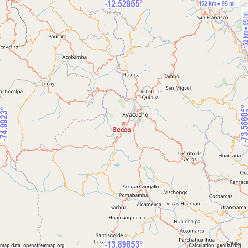
Socos GPS coordinates[2]
13° 12' 54" South, 74° 17' 21.012" West
| Map corner | latitude | longitude |
|---|---|---|
| Upper-left | -12.52955°, | -74.9923° |
| Center: | -13.215°, | -74.28917° |
| Lower-right: | -13.89853°, | -73.58605° |
| Map W x H: | 152.2×152.2 km | = 94.6×94.6mi |
| max Lat: | -0.96667° ⇑63.2% North |
| Socos: | -13.215° |
| min Lat: | ⇓36.8% South -18.01465° |
| min Long | Socos | max Long |
| -81.30472° | -74.28917° | -69.04167° |
| W 63.6%⇐ | ⇒36.4% E |
Elevation
Elevation of Socos is 3398 m = 11148 ft, and this is 1079.3 m = 3541 ft above average elevation for this country.
| Max E: |
5022 m = 16476 ft | 26.7% |
| Socos | 3398 m 11148 ft | |
| Avg. | 2318.7 m = 7607 ft | |
Min E: |
1 m = 3 ft | 73.3% |
See also: Peru elevation on elevation.city.
Geographical zone
Socos is located in South Torrid zone (between Equator and Tropic of Capricorn). Distance of this Southern Tropic circle is 1136.5 km =706.2 mi to South.| Distance of | km | miles | from Socos |
|---|---|---|---|
| Equator | 1469.4 | 913 | to North |
| Tropic Capricorn | 1136.5 | 706.2 | to South |
| Antarctic Circle | 5931.8 | 3685.8 | to South |
| South Pole | 8537.7 | 5305.1 | to South |


Nearby cities:
15 places around Socos: (largest is in red/bold)
• Acocro
26.6 km =16.5 mi,  90°
90°
• Antaparco
20.6 km =12.8 mi,  319°
319°
• Ayacucho
9.5 km =5.9 mi,  48°
48°
• Carmen Alto
7.9 km =4.9 mi,  62°
62°
• Chiara
11.2 km =7 mi,  125°
125°
• Chincho
28.9 km =18 mi,  343°
343°
• Huamanguilla
25.7 km =16 mi,  27°
27°
• Huanta
31.6 km =19.6 mi,  7°
7°
• Julcamarca
27.9 km =17.3 mi, 323°
• Macachacra
27.5 km =17.1 mi,  20°
20°
• Pacaycasa
19.4 km =12.1 mi, 24°
• Quinua
24.6 km =15.3 mi,  41°
41°
• Tambillo
19.4 km =12.1 mi,  82°
82°
• Ticllas
10.3 km =6.4 mi,  332°
332°
• Vinchos
7.5 km =4.7 mi,  247°
247°
Sources, notices
• [Note1] Compared only with cities in Peru existing in our database
• [Src1] Map data: © OpenStreetMap contributors (CC-BY-SA)
• [Src2] Other city data from geonames.org with taken over terms of usage.
• [Src3] Geographical zone / Annual Mean Temperature by Robert A. Rohde @ Wikipedia
