Huaura geodata
Huaura (Lima region) is a seat of a third-order administrative division; located in Peru in America/Lima (GMT-5) time zone. With population of 20,723 people, there are 84 cities with bigger population in this country. Compared to other cities in Peru, 55.3% of cities are located further ↓South; 74.1% of cities are located further →East and 91.4% of cities have higher elevation than Huaura. Note1


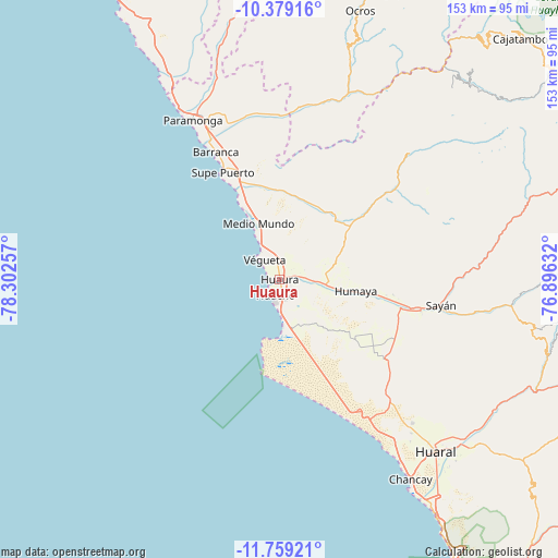
Huaura GPS coordinates[2]
11° 4' 12" South, 77° 35' 57.984" West
| Map corner | latitude | longitude |
|---|---|---|
| Upper-left | -10.37916°, | -78.30257° |
| Center: | -11.07°, | -77.59944° |
| Lower-right: | -11.75921°, | -76.89632° |
| Map W x H: | 153.4×153.5 km | = 95.3×95.4mi |
| max Lat: | -0.96667° ⇑44.7% North |
| Huaura: | -11.07° |
| min Lat: | ⇓55.3% South -18.01465° |
| min Long | Huaura | max Long |
| -81.30472° | -77.59944° | -69.04167° |
| W 25.9%⇐ | ⇒74.1% E |
Elevation
Elevation of Huaura is 72 m = 236 ft, and this is 2246.7 m = 7371 ft below average elevation for this country.
| Max E: |
5022 m = 16476 ft | 91.4% |
| Avg. | 2318.7 m = 7607 ft | |
| Huaura | 72 m = 236 ft | |
Min E: |
1 m = 3 ft | 8.6% |
See also: Peru elevation on elevation.city.
Geographical zone
Huaura is located in South Torrid zone (between Equator and Tropic of Capricorn). Distance of Equator is 1230.9 km =764.8 mi to North.| Distance of | km | miles | from Huaura |
|---|---|---|---|
| Equator | 1230.9 | 764.8 | to North |
| Tropic Capricorn | 1375.1 | 854.4 | to South |
| Antarctic Circle | 6170.3 | 3834 | to South |
| South Pole | 8776.2 | 5453.3 | to South |


Nearby cities:
15 places around Huaura: (largest is in red/bold)
• Ambar
52.2 km =32.4 mi,  44°
44°
• Aucallama
70.9 km =44.1 mi,  139°
139°
• Barranca
40 km =24.9 mi,  332°
332°
• Caleta de Carquín
3.9 km =2.4 mi,  229°
229°
• Chancay
66.5 km =41.3 mi,  146°
146°
• Cruz Blanca
3.1 km =1.9 mi,  165°
165°
• Huacho
4.1 km =2.5 mi,  188°
188°
• Hualmay
3.3 km =2.1 mi,  208°
208°
• Huaral
63.7 km =39.6 mi, 137°
• Paramonga
51.6 km =32.1 mi, 330°
• Pativilca
45.8 km =28.5 mi, 333°
• Puerto Supe
33.7 km =20.9 mi, 332°
• Sayán
44.7 km =27.8 mi,  99°
99°
• Supe
32.7 km =20.3 mi,  337°
337°
• Végueta
7.2 km =4.5 mi,  317°
317°
Sources, notices
• [Note1] Compared only with cities in Peru existing in our database
• [Src1] Map data: © OpenStreetMap contributors (CC-BY-SA)
• [Src2] Other city data from geonames.org with taken over terms of usage.
• [Src3] Geographical zone / Annual Mean Temperature by Robert A. Rohde @ Wikipedia
