Hualmay geodata
Hualmay (Lima region) is a seat of a third-order administrative division; located in Peru in America/Lima (GMT-5) time zone. With population of 26,658 people, there are 66 cities with bigger population in this country. Compared to other cities in Peru, 55% of cities are located further ↓South; 74.5% of cities are located further →East and 93.7% of cities have higher elevation than Hualmay. Note1


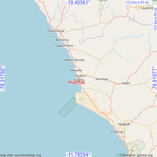
Hualmay GPS coordinates[2]
11° 5' 47.004" South, 77° 36' 50.004" West
| Map corner | latitude | longitude |
|---|---|---|
| Upper-left | -10.40561°, | -78.31702° |
| Center: | -11.09639°, | -77.61389° |
| Lower-right: | -11.78554°, | -76.91077° |
| Map W x H: | 153.4×153.4 km | = 95.3×95.3mi |
| max Lat: | -0.96667° ⇑45% North |
| Hualmay: | -11.09639° |
| min Lat: | ⇓55% South -18.01465° |
| min Long | Hualmay | max Long |
| -81.30472° | -77.61389° | -69.04167° |
| W 25.5%⇐ | ⇒74.5% E |
Elevation
Elevation of Hualmay is 39 m = 128 ft, and this is 2279.7 m = 7479 ft below average elevation for this country.
| Max E: |
5022 m = 16476 ft | 93.7% |
| Avg. | 2318.7 m = 7607 ft | |
| Hualmay | 39 m = 128 ft | |
Min E: |
1 m = 3 ft | 6.3% |
See also: Peru elevation on elevation.city.
Geographical zone
Hualmay is located in South Torrid zone (between Equator and Tropic of Capricorn). Distance of Equator is 1233.8 km =766.6 mi to North.| Distance of | km | miles | from Hualmay |
|---|---|---|---|
| Equator | 1233.8 | 766.6 | to North |
| Tropic Capricorn | 1372.1 | 852.6 | to South |
| Antarctic Circle | 6167.4 | 3832.2 | to South |
| South Pole | 8773.3 | 5451.5 | to South |


Nearby cities:
15 places around Hualmay: (largest is in red/bold)
• Ambar
55.4 km =34.4 mi,  43°
43°
• Aucallama
69.7 km =43.3 mi,  137°
137°
• Barranca
42 km =26.1 mi,  336°
336°
• Caleta de Carquín
1.5 km =0.9 mi,  287°
287°
• Chancay
64.9 km =40.3 mi, 144°
• Cruz Blanca
2.3 km =1.4 mi,  92°
92°
• Huacho
1.5 km =0.9 mi, 139°
• Huaral
62.7 km =39 mi, 135°
• Huaura
3.3 km =2.1 mi,  28°
28°
• Paramonga
53.5 km =33.2 mi,  333°
333°
• Pativilca
47.8 km =29.7 mi, 337°
• Puerto Supe
35.7 km =22.2 mi, 336°
• Sayán
45.9 km =28.5 mi,  95°
95°
• Supe
35 km =21.7 mi, 341°
• Végueta
8.8 km =5.5 mi, 338°
Sources, notices
• [Note1] Compared only with cities in Peru existing in our database
• [Src1] Map data: © OpenStreetMap contributors (CC-BY-SA)
• [Src2] Other city data from geonames.org with taken over terms of usage.
• [Src3] Geographical zone / Annual Mean Temperature by Robert A. Rohde @ Wikipedia
