Toro geodata
Toro (Arequipa) is a seat of a third-order administrative division; located in Peru in America/Lima (GMT-5) time zone. In our database, there are 305 cities with bigger population. Compared to other cities in Peru, 87.8% of cities are located further ↑North; 74% of cities are located further ←West and 52.6% of cities have lower elevation than Toro. Note1


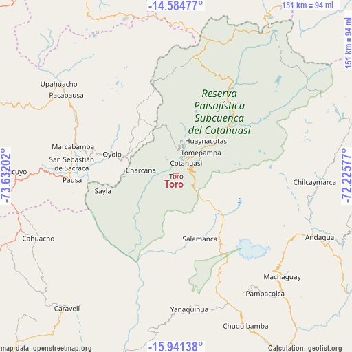
Toro GPS coordinates[2]
15° 15' 51.012" South, 72° 55' 44.004" West
| Map corner | latitude | longitude |
|---|---|---|
| Upper-left | -14.58477°, | -73.63202° |
| Center: | -15.26417°, | -72.92889° |
| Lower-right: | -15.94138°, | -72.22577° |
| Map W x H: | 150.8×150.8 km | = 93.7×93.7mi |
| max Lat: | -0.96667° ⇑87.8% North |
| Toro: | -15.26417° |
| min Lat: | ⇓12.2% South -18.01465° |
| min Long | Toro | max Long |
| -81.30472° | -72.92889° | -69.04167° |
| W 74%⇐ | ⇒26% E |
Elevation
Elevation of Toro is 2953 m = 9688 ft, and this is 634.3 m = 2081 ft above average elevation for this country.
| Max E: |
5022 m = 16476 ft | 47.4% |
| Toro | 2953 m 9688 ft | |
| Avg. | 2318.7 m = 7607 ft | |
Min E: |
1 m = 3 ft | 52.6% |
See also: Peru elevation on elevation.city.
Geographical zone
Toro is located in South Torrid zone (between Equator and Tropic of Capricorn). Distance of this Southern Tropic circle is 908.7 km =564.6 mi to South.| Distance of | km | miles | from Toro |
|---|---|---|---|
| Equator | 1697.2 | 1054.6 | to North |
| Tropic Capricorn | 908.7 | 564.6 | to South |
| Antarctic Circle | 5704 | 3544.3 | to South |
| South Pole | 8309.8 | 5163.5 | to South |


Nearby cities:
15 places around Toro: (largest is in red/bold)
• Alca
22.7 km =14.1 mi,  50°
50°
• Charcana
15.5 km =9.6 mi,  279°
279°
• Chichas
31.5 km =19.6 mi,  177°
177°
• Colta
40.9 km =25.4 mi,  286°
286°
• Corculla
29.1 km =18.1 mi,  270°
270°
• Cotahuasi
7.1 km =4.4 mi,  37°
37°
• Lampa
45.9 km =28.5 mi, 281°
• Mungui
9.4 km =5.8 mi,  15°
15°
• Oyolo
29.2 km =18.1 mi, 288°
• Pausa
44.8 km =27.8 mi, 267°
• Puyca
34.2 km =21.3 mi, 48°
• Tauria
34.1 km =21.2 mi,  252°
252°
• Taurisma
13 km =8.1 mi, 40°
• Tomepampa
14.6 km =9.1 mi, 46°
• Velinga
10 km =6.2 mi,  264°
264°
Sources, notices
• [Note1] Compared only with cities in Peru existing in our database
• [Src1] Map data: © OpenStreetMap contributors (CC-BY-SA)
• [Src2] Other city data from geonames.org with taken over terms of usage.
• [Src3] Geographical zone / Annual Mean Temperature by Robert A. Rohde @ Wikipedia
