Comas geodata
Comas (Junin) is a seat of a third-order administrative division; located in Peru in America/Lima (GMT-5) time zone. In our database, there are 305 cities with bigger population. Compared to other cities in Peru, 51% of cities are located further ↓South; 58.3% of cities are located further ←West and 65.7% of cities have lower elevation than Comas. Note1


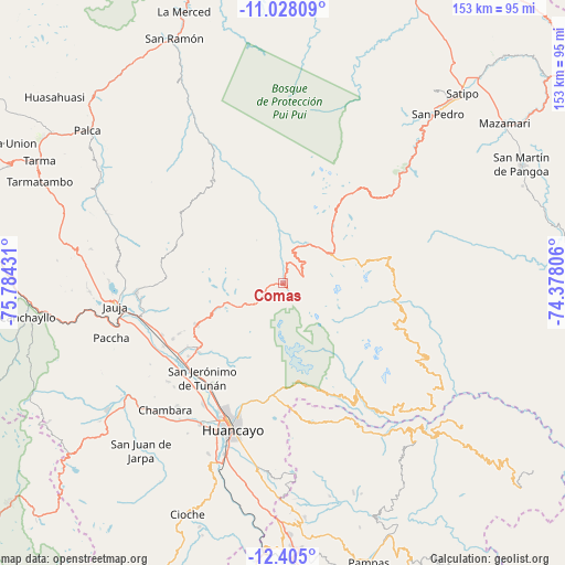
Comas GPS coordinates[2]
11° 43' 2.64" South, 75° 4' 52.248" West
| Map corner | latitude | longitude |
|---|---|---|
| Upper-left | -11.02809°, | -75.78431° |
| Center: | -11.7174°, | -75.08118° |
| Lower-right: | -12.405°, | -74.37806° |
| Map W x H: | 153.1×153.1 km | = 95.1×95.1mi |
| max Lat: | -0.96667° ⇑49% North |
| Comas: | -11.7174° |
| min Lat: | ⇓51% South -18.01465° |
| min Long | Comas | max Long |
| -81.30472° | -75.08118° | -69.04167° |
| W 58.3%⇐ | ⇒41.7% E |
Elevation
Elevation of Comas is 3268 m = 10722 ft, and this is 949.3 m = 3115 ft above average elevation for this country.
| Max E: |
5022 m = 16476 ft | 34.3% |
| Comas | 3268 m 10722 ft | |
| Avg. | 2318.7 m = 7607 ft | |
Min E: |
1 m = 3 ft | 65.7% |
See also: Peru elevation on elevation.city.
Geographical zone
Comas is located in South Torrid zone (between Equator and Tropic of Capricorn). Distance of Equator is 1302.9 km =809.6 mi to North.| Distance of | km | miles | from Comas |
|---|---|---|---|
| Equator | 1302.9 | 809.6 | to North |
| Tropic Capricorn | 1303.1 | 809.7 | to South |
| Antarctic Circle | 6098.3 | 3789.3 | to South |
| South Pole | 8704.2 | 5408.5 | to South |


Nearby cities:
15 places around Comas: (largest is in red/bold)
• Andamarca
30.4 km =18.9 mi,  93°
93°
• Apata
33.3 km =20.7 mi,  242°
242°
• Cochas
7.1 km =4.4 mi,  342°
342°
• Concepción
33.7 km =20.9 mi,  228°
228°
• Hualhuas
33.7 km =20.9 mi,  213°
213°
• Ingenio
27.7 km =17.2 mi, 226°
• Masma Chicche
33.2 km =20.6 mi,  256°
256°
• Matahuasi
34.5 km =21.4 mi, 235°
• Mucllo
11.3 km =7 mi,  354°
354°
• Quichuay
29.4 km =18.3 mi, 229°
• Quilcas
31.1 km =19.3 mi,  218°
218°
• San Agustin
34.1 km =21.2 mi, 213°
• San Jerónimo
34.5 km =21.4 mi, 219°
• San Lorenzo
35.7 km =22.2 mi,  246°
246°
• Saño
32.8 km =20.4 mi, 215°
Sources, notices
• [Note1] Compared only with cities in Peru existing in our database
• [Src1] Map data: © OpenStreetMap contributors (CC-BY-SA)
• [Src2] Other city data from geonames.org with taken over terms of usage.
• [Src3] Geographical zone / Annual Mean Temperature by Robert A. Rohde @ Wikipedia
