Cochas geodata
Cochas (Junin) is a seat of a third-order administrative division; located in Peru in America/Lima (GMT-5) time zone. In our database, there are 305 cities with bigger population. Compared to other cities in Peru, 51.6% of cities are located further ↓South; 58% of cities are located further ←West and 60.8% of cities have lower elevation than Cochas. Note1


Cochas GPS coordinates[2]
11° 39' 25.524" South, 75° 6' 4.284" West
| Map corner | latitude | longitude |
|---|---|---|
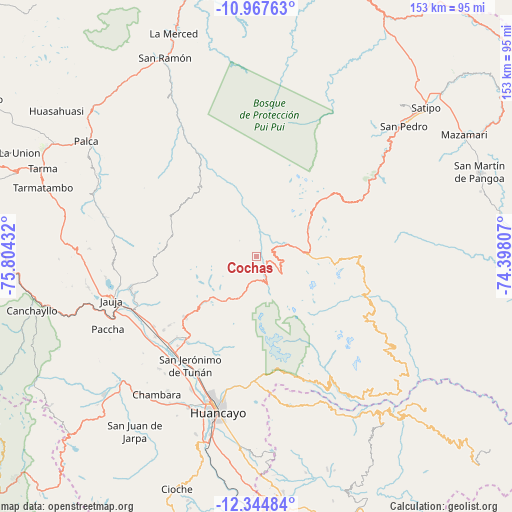
| Upper-left | -10.96763°, | -75.80432° |
| Center: | -11.65709°, | -75.10119° |
| Lower-right: | -12.34484°, | -74.39807° |
| Map W x H: | 153.1×153.1 km | = 95.1×95.1mi |
| max Lat: | -0.96667° ⇑48.4% North |
| Cochas: | -11.65709° |
| min Lat: | ⇓51.6% South -18.01465° |
| min Long | Cochas | max Long |
| -81.30472° | -75.10119° | -69.04167° |
| W 58%⇐ | ⇒42% E |
Elevation
Elevation of Cochas is 3176 m = 10420 ft, and this is 857.3 m = 2813 ft above average elevation for this country.
| Max E: |
5022 m = 16476 ft | 39.2% |
| Cochas | 3176 m 10420 ft | |
| Avg. | 2318.7 m = 7607 ft | |
Min E: |
1 m = 3 ft | 60.8% |
See also: Peru elevation on elevation.city.
Geographical zone
Cochas is located in South Torrid zone (between Equator and Tropic of Capricorn). Distance of Equator is 1296.1 km =805.4 mi to North.| Distance of | km | miles | from Cochas |
|---|---|---|---|
| Equator | 1296.1 | 805.4 | to North |
| Tropic Capricorn | 1309.8 | 813.9 | to South |
| Antarctic Circle | 6105 | 3793.5 | to South |
| South Pole | 8710.9 | 5412.7 | to South |


Nearby cities:
15 places around Cochas: (largest is in red/bold)
• Andamarca
33.5 km =20.8 mi,  104°
104°
• Apata
35.2 km =21.9 mi,  231°
231°
• Comas
7.1 km =4.4 mi,  162°
162°
• Concepción
37.1 km =23.1 mi,  218°
218°
• Ingenio
31.4 km =19.5 mi,  214°
214°
• Julcan
38.2 km =23.7 mi,  252°
252°
• Masma
38.1 km =23.7 mi, 248°
• Masma Chicche
33.4 km =20.8 mi,  244°
244°
• Matahuasi
37.1 km =23.1 mi, 225°
• Molinos
38.3 km =23.8 mi,  256°
256°
• Mucllo
4.7 km =2.9 mi,  13°
13°
• Quichuay
32.8 km =20.4 mi, 217°
• Quilcas
35.5 km =22.1 mi, 209°
• San Lorenzo
37.1 km =23.1 mi, 235°
• Saño
37.4 km =23.2 mi, 206°
Sources, notices
• [Note1] Compared only with cities in Peru existing in our database
• [Src1] Map data: © OpenStreetMap contributors (CC-BY-SA)
• [Src2] Other city data from geonames.org with taken over terms of usage.
• [Src3] Geographical zone / Annual Mean Temperature by Robert A. Rohde @ Wikipedia
