Chichas geodata
Chichas (Arequipa) is a seat of a third-order administrative division; located in Peru in America/Lima (GMT-5) time zone. In our database, there are 305 cities with bigger population. Compared to other cities in Peru, 89.7% of cities are located further ↑North; 74.1% of cities are located further ←West and 63.9% of cities have higher elevation than Chichas. Note1


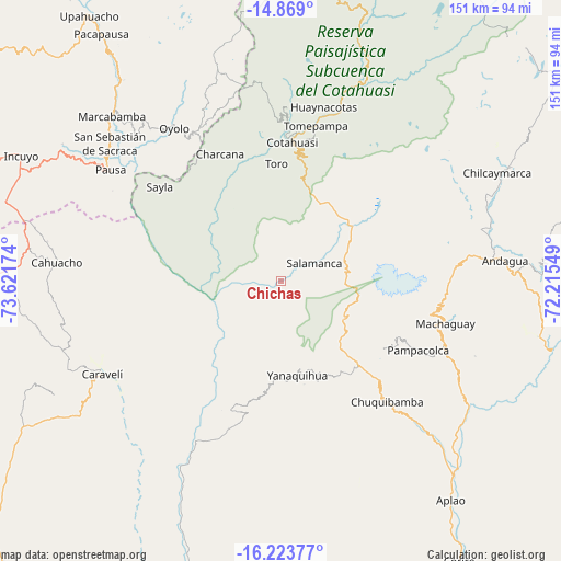
Chichas GPS coordinates[2]
15° 32' 51" South, 72° 55' 6.996" West
| Map corner | latitude | longitude |
|---|---|---|
| Upper-left | -14.869°, | -73.62174° |
| Center: | -15.5475°, | -72.91861° |
| Lower-right: | -16.22377°, | -72.21549° |
| Map W x H: | 150.6×150.6 km | = 93.6×93.6mi |
| max Lat: | -0.96667° ⇑89.7% North |
| Chichas: | -15.5475° |
| min Lat: | ⇓10.3% South -18.01465° |
| min Long | Chichas | max Long |
| -81.30472° | -72.91861° | -69.04167° |
| W 74.1%⇐ | ⇒25.9% E |
Elevation
Elevation of Chichas is 2152 m = 7060 ft, and this is 166.7 m = 547 ft below average elevation for this country.
| Max E: |
5022 m = 16476 ft | 63.9% |
| Avg. | 2318.7 m = 7607 ft | |
| Chichas | 2152 m = 7060 ft | |
Min E: |
1 m = 3 ft | 36.1% |
See also: Peru elevation on elevation.city.
Geographical zone
Chichas is located in South Torrid zone (between Equator and Tropic of Capricorn). Distance of this Southern Tropic circle is 877.2 km =545.1 mi to South.| Distance of | km | miles | from Chichas |
|---|---|---|---|
| Equator | 1728.7 | 1074.2 | to North |
| Tropic Capricorn | 877.2 | 545.1 | to South |
| Antarctic Circle | 5672.5 | 3524.7 | to South |
| South Pole | 8278.3 | 5143.9 | to South |


Nearby cities:
15 places around Chichas: (largest is in red/bold)
• Andaray
28.4 km =17.6 mi,  167°
167°
• Charcana
37.8 km =23.5 mi,  334°
334°
• Chuquibamba
43 km =26.7 mi,  138°
138°
• Corculla
43.8 km =27.2 mi,  316°
316°
• Cotahuasi
37.3 km =23.2 mi,  4°
4°
• Iray
46.5 km =28.9 mi, 137°
• Mungui
40.6 km =25.2 mi, 1°
• Pampacolca
41.2 km =25.6 mi,  116°
116°
• Tauria
39.8 km =24.7 mi,  302°
302°
• Taurisma
42.1 km =26.2 mi,  10°
10°
• Tomepampa
42.7 km =26.5 mi, 12°
• Toro
31.5 km =19.6 mi,  357°
357°
• Velinga
32.4 km =20.1 mi,  340°
340°
• Viraco
43.8 km =27.2 mi,  106°
106°
• Yanaquihua
25.6 km =15.9 mi, 169°
Sources, notices
• [Note1] Compared only with cities in Peru existing in our database
• [Src1] Map data: © OpenStreetMap contributors (CC-BY-SA)
• [Src2] Other city data from geonames.org with taken over terms of usage.
• [Src3] Geographical zone / Annual Mean Temperature by Robert A. Rohde @ Wikipedia
