Chiara geodata
Chiara (Apurímac) is a seat of a third-order administrative division; located in Peru in America/Lima (GMT-5) time zone. In our database, there are 305 cities with bigger population. Compared to other cities in Peru, 72.2% of cities are located further ↑North; 68.8% of cities are located further ←West and 69% of cities have lower elevation than Chiara. Note1


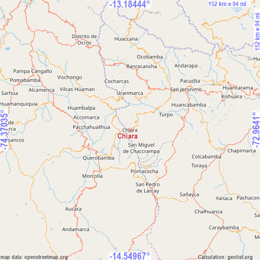
Chiara GPS coordinates[2]
13° 52' 5.016" South, 73° 40' 1.992" West
| Map corner | latitude | longitude |
|---|---|---|
| Upper-left | -13.18444°, | -74.37035° |
| Center: | -13.86806°, | -73.66722° |
| Lower-right: | -14.54967°, | -72.9641° |
| Map W x H: | 151.8×151.8 km | = 94.3×94.3mi |
| max Lat: | -0.96667° ⇑72.2% North |
| Chiara: | -13.86806° |
| min Lat: | ⇓27.8% South -18.01465° |
| min Long | Chiara | max Long |
| -81.30472° | -73.66722° | -69.04167° |
| W 68.8%⇐ | ⇒31.2% E |
Elevation
Elevation of Chiara is 3326 m = 10912 ft, and this is 1007.3 m = 3305 ft above average elevation for this country.
| Max E: |
5022 m = 16476 ft | 31% |
| Chiara | 3326 m 10912 ft | |
| Avg. | 2318.7 m = 7607 ft | |
Min E: |
1 m = 3 ft | 69% |
See also: Peru elevation on elevation.city.
Geographical zone
Chiara is located in South Torrid zone (between Equator and Tropic of Capricorn). Distance of this Southern Tropic circle is 1063.9 km =661.1 mi to South.| Distance of | km | miles | from Chiara |
|---|---|---|---|
| Equator | 1542 | 958.2 | to North |
| Tropic Capricorn | 1063.9 | 661.1 | to South |
| Antarctic Circle | 5859.2 | 3640.7 | to South |
| South Pole | 8465.1 | 5260 | to South |


Nearby cities:
15 places around Chiara: (largest is in red/bold)
• Accomarca
26.6 km =16.5 mi,  286°
286°
• Canaria
26.4 km =16.4 mi,  257°
257°
• Carhuanca
19.1 km =11.9 mi,  316°
316°
• Chaccrampa
12 km =7.5 mi,  148°
148°
• Chalcos
9.6 km =6 mi,  283°
283°
• Cocharcas
29.8 km =18.5 mi,  344°
344°
• Huancaray
19.4 km =12.1 mi,  51°
51°
• Huayana
21 km =13 mi,  162°
162°
• Paico
19 km =11.8 mi,  172°
172°
• Pomacocha
25.5 km =15.8 mi, 160°
• Querobamba
24.6 km =15.3 mi,  229°
229°
• Saurama
21.8 km =13.5 mi,  333°
333°
• Soras
28.3 km =17.6 mi, 166°
• Turpo
22.8 km =14.2 mi,  66°
66°
• Umamarca
23.3 km =14.5 mi, 151°
Sources, notices
• [Note1] Compared only with cities in Peru existing in our database
• [Src1] Map data: © OpenStreetMap contributors (CC-BY-SA)
• [Src2] Other city data from geonames.org with taken over terms of usage.
• [Src3] Geographical zone / Annual Mean Temperature by Robert A. Rohde @ Wikipedia
