Pomacocha geodata
Pomacocha (Apurímac) is a seat of a third-order administrative division; located in Peru in America/Lima (GMT-5) time zone. In our database, there are 305 cities with bigger population. Compared to other cities in Peru, 75.5% of cities are located further ↑North; 69.4% of cities are located further ←West and 85.1% of cities have lower elevation than Pomacocha. Note1


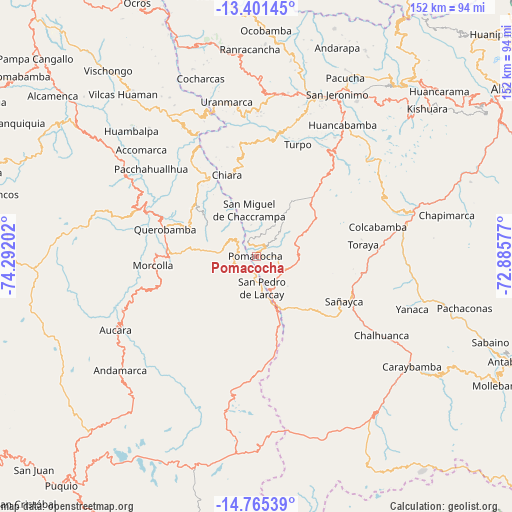
Pomacocha GPS coordinates[2]
14° 5' 3.984" South, 73° 35' 20.004" West
| Map corner | latitude | longitude |
|---|---|---|
| Upper-left | -13.40145°, | -74.29202° |
| Center: | -14.08444°, | -73.58889° |
| Lower-right: | -14.76539°, | -72.88577° |
| Map W x H: | 151.7×151.7 km | = 94.3×94.3mi |
| max Lat: | -0.96667° ⇑75.5% North |
| Pomacocha: | -14.08444° |
| min Lat: | ⇓24.5% South -18.01465° |
| min Long | Pomacocha | max Long |
| -81.30472° | -73.58889° | -69.04167° |
| W 69.4%⇐ | ⇒30.6% E |
Elevation
Elevation of Pomacocha is 3661 m = 12011 ft, and this is 1342.3 m = 4404 ft above average elevation for this country.
| Max E: |
5022 m = 16476 ft | 14.9% |
| Pomacocha | 3661 m 12011 ft | |
| Avg. | 2318.7 m = 7607 ft | |
Min E: |
1 m = 3 ft | 85.1% |
See also: Peru elevation on elevation.city.
Geographical zone
Pomacocha is located in South Torrid zone (between Equator and Tropic of Capricorn). Distance of this Southern Tropic circle is 1039.9 km =646.2 mi to South.| Distance of | km | miles | from Pomacocha |
|---|---|---|---|
| Equator | 1566 | 973.1 | to North |
| Tropic Capricorn | 1039.9 | 646.2 | to South |
| Antarctic Circle | 5835.1 | 3625.8 | to South |
| South Pole | 8441 | 5245 | to South |


Nearby cities:
15 places around Pomacocha: (largest is in red/bold)
• Capaya
29.5 km =18.3 mi,  97°
97°
• Chaccrampa
14 km =8.7 mi,  351°
351°
• Chalcos
31.7 km =19.7 mi,  326°
326°
• Chiara
25.5 km =15.8 mi,  340°
340°
• Huacaña
33.6 km =20.9 mi,  252°
252°
• Huayana
4.6 km =2.9 mi, 330°
• Morcolla
30.6 km =19 mi,  264°
264°
• Paico
7.9 km =4.9 mi,  311°
311°
• Pampachiri
12.4 km =7.7 mi,  156°
156°
• Querobamba
28.2 km =17.5 mi,  286°
286°
• Sañayca
30.5 km =19 mi,  116°
116°
• Soras
3.8 km =2.4 mi,  206°
206°
• Soraya
31 km =19.3 mi,  106°
106°
• Toraya
31.7 km =19.7 mi,  83°
83°
• Umamarca
4.3 km =2.7 mi,  35°
35°
Sources, notices
• [Note1] Compared only with cities in Peru existing in our database
• [Src1] Map data: © OpenStreetMap contributors (CC-BY-SA)
• [Src2] Other city data from geonames.org with taken over terms of usage.
• [Src3] Geographical zone / Annual Mean Temperature by Robert A. Rohde @ Wikipedia
