Umamarca geodata
Umamarca (Apurímac) is a seat of a third-order administrative division; located in Peru in America/Lima (GMT-5) time zone. In our database, there are 305 cities with bigger population. Compared to other cities in Peru, 74.8% of cities are located further ↑North; 69.7% of cities are located further ←West and 72.2% of cities have lower elevation than Umamarca. Note1
Administrative division(s):
- Level 1: Apurímac
- Level 2: Provincia de Andahuaylas
- Level 3: Tumay Huaraca


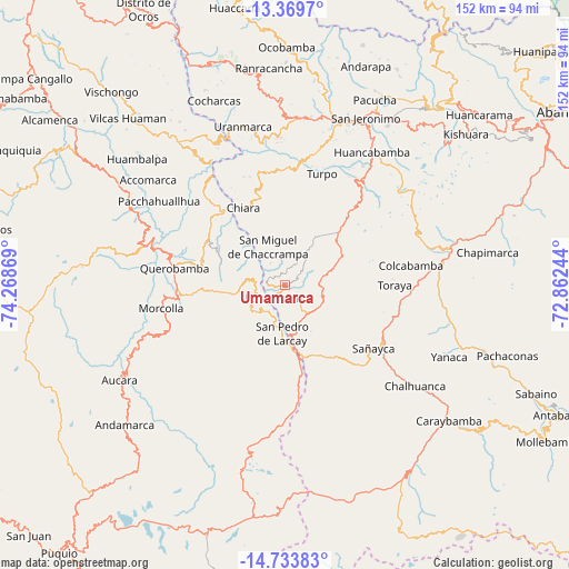
Umamarca GPS coordinates[2]
14° 3' 10.008" South, 73° 33' 56.016" West
| Map corner | latitude | longitude |
|---|---|---|
| Upper-left | -13.3697°, | -74.26869° |
| Center: | -14.05278°, | -73.56556° |
| Lower-right: | -14.73383°, | -72.86244° |
| Map W x H: | 151.7×151.7 km | = 94.3×94.3mi |
| max Lat: | -0.96667° ⇑74.8% North |
| Umamarca: | -14.05278° |
| min Lat: | ⇓25.2% South -18.01465° |
| min Long | Umamarca | max Long |
| -81.30472° | -73.56556° | -69.04167° |
| W 69.7%⇐ | ⇒30.3% E |
Elevation
Elevation of Umamarca is 3383 m = 11099 ft, and this is 1064.3 m = 3492 ft above average elevation for this country.
| Max E: |
5022 m = 16476 ft | 27.8% |
| Umamarca | 3383 m 11099 ft | |
| Avg. | 2318.7 m = 7607 ft | |
Min E: |
1 m = 3 ft | 72.2% |
See also: Peru elevation on elevation.city.
Geographical zone
Umamarca is located in South Torrid zone (between Equator and Tropic of Capricorn). Distance of this Southern Tropic circle is 1043.4 km =648.3 mi to South.| Distance of | km | miles | from Umamarca |
|---|---|---|---|
| Equator | 1562.5 | 970.9 | to North |
| Tropic Capricorn | 1043.4 | 648.3 | to South |
| Antarctic Circle | 5838.7 | 3628 | to South |
| South Pole | 8444.5 | 5247.2 | to South |


Nearby cities:
15 places around Umamarca: (largest is in red/bold)
• Capaya
27.7 km =17.2 mi,  105°
105°
• Chaccrampa
11.4 km =7.1 mi,  335°
335°
• Chalcos
30.5 km =19 mi,  318°
318°
• Chiara
23.3 km =14.5 mi,  331°
331°
• Huancaray
33 km =20.5 mi,  7°
7°
• Huayana
4.8 km =3 mi,  275°
275°
• Paico
8.6 km =5.3 mi, 281°
• Pampachiri
15.1 km =9.4 mi,  171°
171°
• Pomacocha
4.3 km =2.7 mi,  215°
215°
• Querobamba
29.9 km =18.6 mi, 278°
• Sañayca
30.1 km =18.7 mi,  124°
124°
• Soras
8.1 km =5 mi,  211°
211°
• Soraya
29.9 km =18.6 mi, 114°
• Toraya
28.9 km =18 mi,  89°
89°
• Turpo
31.4 km =19.5 mi,  18°
18°
Sources, notices
• [Note1] Compared only with cities in Peru existing in our database
• [Src1] Map data: © OpenStreetMap contributors (CC-BY-SA)
• [Src2] Other city data from geonames.org with taken over terms of usage.
• [Src3] Geographical zone / Annual Mean Temperature by Robert A. Rohde @ Wikipedia
