Challabamba geodata
Challabamba (Cusco) is a seat of a third-order administrative division; located in Peru in America/Lima (GMT-5) time zone. In our database, there are 305 cities with bigger population. Compared to other cities in Peru, 63.2% of cities are located further ↑North; 84.1% of cities are located further ←West and 52% of cities have lower elevation than Challabamba. Note1


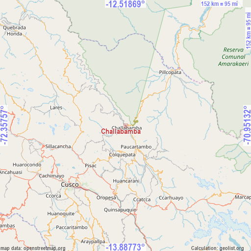
Challabamba GPS coordinates[2]
13° 12' 15.012" South, 71° 39' 15.984" West
| Map corner | latitude | longitude |
|---|---|---|
| Upper-left | -12.51869°, | -72.35757° |
| Center: | -13.20417°, | -71.65444° |
| Lower-right: | -13.88773°, | -70.95132° |
| Map W x H: | 152.2×152.2 km | = 94.6×94.6mi |
| max Lat: | -0.96667° ⇑63.2% North |
| Challabamba: | -13.20417° |
| min Lat: | ⇓36.8% South -18.01465° |
| min Long | Challabamba | max Long |
| -81.30472° | -71.65444° | -69.04167° |
| W 84.1%⇐ | ⇒15.9% E |
Elevation
Elevation of Challabamba is 2926 m = 9600 ft, and this is 607.3 m = 1992 ft above average elevation for this country.
| Max E: |
5022 m = 16476 ft | 48% |
| Challabamba | 2926 m 9600 ft | |
| Avg. | 2318.7 m = 7607 ft | |
Min E: |
1 m = 3 ft | 52% |
See also: Peru elevation on elevation.city.
Geographical zone
Challabamba is located in South Torrid zone (between Equator and Tropic of Capricorn). Distance of this Southern Tropic circle is 1137.8 km =707 mi to South.| Distance of | km | miles | from Challabamba |
|---|---|---|---|
| Equator | 1468.2 | 912.3 | to North |
| Tropic Capricorn | 1137.8 | 707 | to South |
| Antarctic Circle | 5933 | 3686.6 | to South |
| South Pole | 8538.9 | 5305.8 | to South |


Nearby cities:
15 places around Challabamba: (largest is in red/bold)
• Caicay
43.7 km =27.2 mi,  186°
186°
• Calca
35.1 km =21.8 mi,  245°
245°
• Ccatca
45.7 km =28.4 mi,  167°
167°
• Chinchero
47.4 km =29.5 mi,  243°
243°
• Colquepata
16.9 km =10.5 mi, 185°
• Coya
33.5 km =20.8 mi,  232°
232°
• Huayllabamba
46.9 km =29.1 mi, 251°
• Lamay
34.2 km =21.3 mi, 238°
• Lares
43.6 km =27.1 mi,  284°
284°
• Oropesa
45 km =28 mi,  196°
196°
• Paucartambo
14 km =8.7 mi,  151°
151°
• Pisac
32 km =19.9 mi,  220°
220°
• San Salvador
34.7 km =21.6 mi, 201°
• Saylla
44.9 km =27.9 mi,  207°
207°
• Taray
33.9 km =21.1 mi, 222°
Sources, notices
• [Note1] Compared only with cities in Peru existing in our database
• [Src1] Map data: © OpenStreetMap contributors (CC-BY-SA)
• [Src2] Other city data from geonames.org with taken over terms of usage.
• [Src3] Geographical zone / Annual Mean Temperature by Robert A. Rohde @ Wikipedia
