Capacmarca geodata
Capacmarca (Cusco) is a seat of a third-order administrative division; located in Peru in America/Lima (GMT-5) time zone. In our database, there are 305 cities with bigger population. Compared to other cities in Peru, 73.9% of cities are located further ↑North; 81% of cities are located further ←West and 84.1% of cities have lower elevation than Capacmarca. Note1


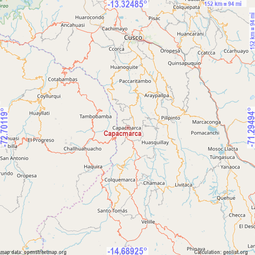
Capacmarca GPS coordinates[2]
14° 0' 29.016" South, 71° 59' 53.016" West
| Map corner | latitude | longitude |
|---|---|---|
| Upper-left | -13.32485°, | -72.70119° |
| Center: | -14.00806°, | -71.99806° |
| Lower-right: | -14.68925°, | -71.29494° |
| Map W x H: | 151.7×151.7 km | = 94.3×94.3mi |
| max Lat: | -0.96667° ⇑73.9% North |
| Capacmarca: | -14.00806° |
| min Lat: | ⇓26.1% South -18.01465° |
| min Long | Capacmarca | max Long |
| -81.30472° | -71.99806° | -69.04167° |
| W 81%⇐ | ⇒19% E |
Elevation
Elevation of Capacmarca is 3624 m = 11890 ft, and this is 1305.3 m = 4282 ft above average elevation for this country.
| Max E: |
5022 m = 16476 ft | 15.9% |
| Capacmarca | 3624 m 11890 ft | |
| Avg. | 2318.7 m = 7607 ft | |
Min E: |
1 m = 3 ft | 84.1% |
See also: Peru elevation on elevation.city.
Geographical zone
Capacmarca is located in South Torrid zone (between Equator and Tropic of Capricorn). Distance of this Southern Tropic circle is 1048.4 km =651.4 mi to South.| Distance of | km | miles | from Capacmarca |
|---|---|---|---|
| Equator | 1557.6 | 967.8 | to North |
| Tropic Capricorn | 1048.4 | 651.4 | to South |
| Antarctic Circle | 5843.6 | 3631 | to South |
| South Pole | 8449.5 | 5250.3 | to South |


Nearby cities:
15 places around Capacmarca: (largest is in red/bold)
• Accha
18.9 km =11.7 mi,  78°
78°
• Acomayo
35.7 km =22.2 mi,  73°
73°
• Acos
28.9 km =18 mi, 77°
• Ccapi
19.4 km =12.1 mi,  333°
333°
• Challhuahuacho
29.7 km =18.5 mi,  246°
246°
• Colcha
27.3 km =17 mi,  50°
50°
• Colquemarca
30.8 km =19.1 mi,  188°
188°
• Haquira
30.8 km =19.1 mi,  222°
222°
• Huanoquite
36.2 km =22.5 mi,  356°
356°
• Mara
14.6 km =9.1 mi,  234°
234°
• Omacha
28.7 km =17.8 mi,  104°
104°
• Paccaritambo
28.1 km =17.5 mi,  9°
9°
• Paruro
31.6 km =19.6 mi,  30°
30°
• Pillpinto
26.4 km =16.4 mi, 76°
• Tambobamba
20 km =12.4 mi,  290°
290°
Sources, notices
• [Note1] Compared only with cities in Peru existing in our database
• [Src1] Map data: © OpenStreetMap contributors (CC-BY-SA)
• [Src2] Other city data from geonames.org with taken over terms of usage.
• [Src3] Geographical zone / Annual Mean Temperature by Robert A. Rohde @ Wikipedia
