Colquemarca geodata
Colquemarca (Cusco) is a seat of a third-order administrative division; located in Peru in America/Lima (GMT-5) time zone. In our database, there are 305 cities with bigger population. Compared to other cities in Peru, 79.9% of cities are located further ↑North; 80.6% of cities are located further ←West and 82.4% of cities have lower elevation than Colquemarca. Note1


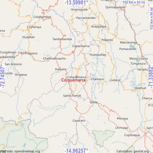
Colquemarca GPS coordinates[2]
14° 16' 55.992" South, 72° 2' 30.984" West
| Map corner | latitude | longitude |
|---|---|---|
| Upper-left | -13.59981°, | -72.74507° |
| Center: | -14.28222°, | -72.04194° |
| Lower-right: | -14.96257°, | -71.33882° |
| Map W x H: | 151.5×151.5 km | = 94.1×94.1mi |
| max Lat: | -0.96667° ⇑79.9% North |
| Colquemarca: | -14.28222° |
| min Lat: | ⇓20.1% South -18.01465° |
| min Long | Colquemarca | max Long |
| -81.30472° | -72.04194° | -69.04167° |
| W 80.6%⇐ | ⇒19.4% E |
Elevation
Elevation of Colquemarca is 3578 m = 11739 ft, and this is 1259.3 m = 4132 ft above average elevation for this country.
| Max E: |
5022 m = 16476 ft | 17.6% |
| Colquemarca | 3578 m 11739 ft | |
| Avg. | 2318.7 m = 7607 ft | |
Min E: |
1 m = 3 ft | 82.4% |
See also: Peru elevation on elevation.city.
Geographical zone
Colquemarca is located in South Torrid zone (between Equator and Tropic of Capricorn). Distance of this Southern Tropic circle is 1017.9 km =632.5 mi to South.| Distance of | km | miles | from Colquemarca |
|---|---|---|---|
| Equator | 1588 | 986.7 | to North |
| Tropic Capricorn | 1017.9 | 632.5 | to South |
| Antarctic Circle | 5813.1 | 3612.1 | to South |
| South Pole | 8419 | 5231.3 | to South |


Nearby cities:
15 places around Colquemarca: (largest is in red/bold)
• Accha
41.4 km =25.7 mi,  34°
34°
• Capacmarca
30.8 km =19.1 mi,  8°
8°
• Cayarani
43.4 km =27 mi,  177°
177°
• Challhuahuacho
29 km =18 mi,  309°
309°
• Chamaca
21.6 km =13.4 mi,  97°
97°
• Haquira
17.7 km =11 mi,  295°
295°
• Livitaca
38.3 km =23.8 mi,  93°
93°
• Llusco
9.5 km =5.9 mi,  235°
235°
• Mara
23 km =14.3 mi,  341°
341°
• Omacha
40.1 km =24.9 mi,  54°
54°
• Pillpinto
47.5 km =29.5 mi,  39°
39°
• Quiñota
10.5 km =6.5 mi,  254°
254°
• Santo Tomas
18.7 km =11.6 mi,  194°
194°
• Tambobamba
40 km =24.9 mi, 339°
• Velille
30.3 km =18.8 mi,  146°
146°
Sources, notices
• [Note1] Compared only with cities in Peru existing in our database
• [Src1] Map data: © OpenStreetMap contributors (CC-BY-SA)
• [Src2] Other city data from geonames.org with taken over terms of usage.
• [Src3] Geographical zone / Annual Mean Temperature by Robert A. Rohde @ Wikipedia
