Ayaviri geodata
Ayaviri (Puno) is a seat of a third-order administrative division; located in Peru in America/Lima (GMT-5) time zone. With population of 19,310 people, there are 87 cities with bigger population in this country. Compared to other cities in Peru, 84.7% of cities are located further ↑North; 92.3% of cities are located further ←West and 91.6% of cities have lower elevation than Ayaviri. Note1


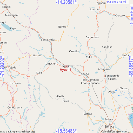
Ayaviri GPS coordinates[2]
14° 53' 11.004" South, 70° 35' 20.004" West
| Map corner | latitude | longitude |
|---|---|---|
| Upper-left | -14.20581°, | -71.29202° |
| Center: | -14.88639°, | -70.58889° |
| Lower-right: | -15.56483°, | -69.88577° |
| Map W x H: | 151.1×151.1 km | = 93.9×93.9mi |
| max Lat: | -0.96667° ⇑84.7% North |
| Ayaviri: | -14.88639° |
| min Lat: | ⇓15.3% South -18.01465° |
| min Long | Ayaviri | max Long |
| -81.30472° | -70.58889° | -69.04167° |
| W 92.3%⇐ | ⇒7.7% E |
Elevation
Elevation of Ayaviri is 3898 m = 12789 ft, and this is 1579.3 m = 5181 ft above average elevation for this country.
| Max E: |
5022 m = 16476 ft | 8.4% |
| Ayaviri | 3898 m 12789 ft | |
| Avg. | 2318.7 m = 7607 ft | |
Min E: |
1 m = 3 ft | 91.6% |
See also: Peru elevation on elevation.city.
Geographical zone
Ayaviri is located in South Torrid zone (between Equator and Tropic of Capricorn). Distance of this Southern Tropic circle is 950.7 km =590.7 mi to South.| Distance of | km | miles | from Ayaviri |
|---|---|---|---|
| Equator | 1655.2 | 1028.5 | to North |
| Tropic Capricorn | 950.7 | 590.7 | to South |
| Antarctic Circle | 5746 | 3570.4 | to South |
| South Pole | 8351.9 | 5189.6 | to South |


Nearby cities:
15 places around Ayaviri: (largest is in red/bold)
• Asillo
28.1 km =17.5 mi,  65°
65°
• Azángaro
42.3 km =26.3 mi,  93°
93°
• Cupi
30.7 km =19.1 mi,  265°
265°
• Lampa
56.8 km =35.3 mi,  155°
155°
• Llalli
32 km =19.9 mi,  260°
260°
• Macari
36.1 km =22.4 mi,  291°
291°
• Nicasio
53 km =32.9 mi,  136°
136°
• Ocuviri
42.4 km =26.3 mi,  233°
233°
• Orurillo
19.2 km =11.9 mi,  25°
25°
• Palca
38.6 km =24 mi,  181°
181°
• Santa Rosa
37.2 km =23.1 mi,  325°
325°
• Tirapata
21.5 km =13.4 mi,  109°
109°
• Umachiri
18.3 km =11.4 mi,  280°
280°
• Vilavila
34.3 km =21.3 mi,  192°
192°
• Ñuñoa
45.7 km =28.4 mi,  353°
353°
Sources, notices
• [Note1] Compared only with cities in Peru existing in our database
• [Src1] Map data: © OpenStreetMap contributors (CC-BY-SA)
• [Src2] Other city data from geonames.org with taken over terms of usage.
• [Src3] Geographical zone / Annual Mean Temperature by Robert A. Rohde @ Wikipedia
