Ñuñoa geodata
Ñuñoa (Puno) is a populated place; located in Peru in America/Lima (GMT-5) time zone. With population of 4,271 people, there are 260 cities with bigger population in this country. Compared to other cities in Peru, 82.3% of cities are located further ↑North; 91.9% of cities are located further ←West and 94.7% of cities have lower elevation than Ñuñoa. Note1


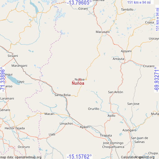
Ñuñoa GPS coordinates[2]
14° 28' 40.368" South, 70° 38' 8.988" West
| Map corner | latitude | longitude |
|---|---|---|
| Upper-left | -13.79605°, | -71.33896° |
| Center: | -14.47788°, | -70.63583° |
| Lower-right: | -15.15762°, | -69.93271° |
| Map W x H: | 151.4×151.4 km | = 94.1×94.1mi |
| max Lat: | -0.96667° ⇑82.3% North |
| Ñuñoa: | -14.47788° |
| min Lat: | ⇓17.7% South -18.01465° |
| min Long | Ñuñoa | max Long |
| -81.30472° | -70.63583° | -69.04167° |
| W 91.9%⇐ | ⇒8.1% E |
Elevation
Elevation of Ñuñoa is 4022 m = 13196 ft, and this is 1703.3 m = 5588 ft above average elevation for this country.
| Max E: |
5022 m = 16476 ft | 5.3% |
| Ñuñoa | 4022 m 13196 ft | |
| Avg. | 2318.7 m = 7607 ft | |
Min E: |
1 m = 3 ft | 94.7% |
See also: Peru elevation on elevation.city.
Geographical zone
Ñuñoa is located in South Torrid zone (between Equator and Tropic of Capricorn). Distance of this Southern Tropic circle is 996.1 km =618.9 mi to South.| Distance of | km | miles | from Ñuñoa |
|---|---|---|---|
| Equator | 1609.8 | 1000.3 | to North |
| Tropic Capricorn | 996.1 | 618.9 | to South |
| Antarctic Circle | 5791.4 | 3598.6 | to South |
| South Pole | 8397.3 | 5217.8 | to South |


Nearby cities:
15 places around Ñuñoa: (largest is in red/bold)
• Antauta
30.2 km =18.8 mi,  73°
73°
• Asillo
45.8 km =28.5 mi,  137°
137°
• Ayaviri
45.7 km =28.4 mi,  173°
173°
• Cupi
54.1 km =33.6 mi,  208°
208°
• Huayna Alcalde
54.7 km =34 mi,  295°
295°
• Layo
55.9 km =34.7 mi,  268°
268°
• Llalli
57.2 km =35.5 mi, 207°
• Macari
43.2 km =26.8 mi,  221°
221°
• Macusani
49 km =30.4 mi,  26°
26°
• Maranganí
59 km =36.7 mi,  283°
283°
• Mosoc Cancha
53.2 km =33.1 mi,  293°
293°
• Orurillo
31 km =19.3 mi,  154°
154°
• Santa Rosa
21.9 km =13.6 mi,  227°
227°
• Tirapata
58.3 km =36.2 mi, 154°
• Umachiri
44.1 km =27.4 mi,  197°
197°
Sources, notices
• [Note1] Compared only with cities in Peru existing in our database
• [Src1] Map data: © OpenStreetMap contributors (CC-BY-SA)
• [Src2] Other city data from geonames.org with taken over terms of usage.
• [Src3] Geographical zone / Annual Mean Temperature by Robert A. Rohde @ Wikipedia
