Puno geodata
Puno is a seat of a first-order administrative division; located in Peru in America/Lima (GMT-5) time zone. With population of 116,552 people, there are 20 cities with bigger population in this country. Compared to other cities in Peru, 93.2% of cities are located further ↑North; 96.3% of cities are located further ←West and 89.2% of cities have lower elevation than Puno. Note1


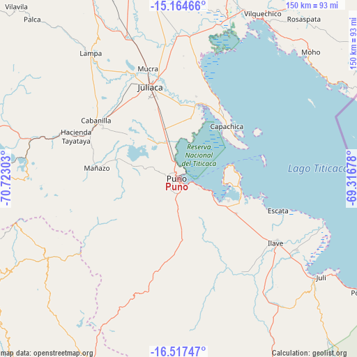
Puno GPS coordinates[2]
15° 50' 31.92" South, 70° 1' 11.64" West
| Map corner | latitude | longitude |
|---|---|---|
| Upper-left | -15.16466°, | -70.72303° |
| Center: | -15.8422°, | -70.0199° |
| Lower-right: | -16.51747°, | -69.31678° |
| Map W x H: | 150.4×150.4 km | = 93.5×93.5mi |
| max Lat: | -0.96667° ⇑93.2% North |
| Puno: | -15.8422° |
| min Lat: | ⇓6.8% South -18.01465° |
| min Long | Puno | max Long |
| -81.30472° | -70.0199° | -69.04167° |
| W 96.3%⇐ | ⇒3.7% E |
Elevation
Elevation of Puno is 3825 m = 12549 ft, and this is 1506.3 m = 4942 ft above average elevation for this country.
| Max E: |
5022 m = 16476 ft | 10.8% |
| Puno | 3825 m 12549 ft | |
| Avg. | 2318.7 m = 7607 ft | |
Min E: |
1 m = 3 ft | 89.2% |
See also: Puno elevation on elevation.city.
Geographical zone
Puno is located in South Torrid zone (between Equator and Tropic of Capricorn). Distance of this Southern Tropic circle is 844.4 km =524.7 mi to South.| Distance of | km | miles | from Puno |
|---|---|---|---|
| Equator | 1761.5 | 1094.5 | to North |
| Tropic Capricorn | 844.4 | 524.7 | to South |
| Antarctic Circle | 5639.7 | 3504.3 | to South |
| South Pole | 8245.6 | 5123.6 | to South |


Nearby cities:
15 places around Puno: (largest is in red/bold)
• Atuncolla
22.5 km =14 mi,  321°
321°
• Cabana
38.3 km =23.8 mi,  303°
303°
• Cabanilla
43.3 km =26.9 mi,  305°
305°
• Capachica
31.8 km =19.8 mi,  43°
43°
• Caracoto
31.8 km =19.8 mi,  344°
344°
• Coata
31.5 km =19.6 mi,  13°
13°
• Huata
25.7 km =16 mi, 12°
• Ilave
46.3 km =28.8 mi,  125°
125°
• Juliaca
39.9 km =24.8 mi, 342°
• Laraqueri
32.5 km =20.2 mi,  185°
185°
• Mañazo
33.9 km =21.1 mi,  277°
277°
• Paucarcolla
12.5 km =7.8 mi,  345°
345°
• Taquile
37 km =23 mi,  76°
76°
• Tiquillaca
19.5 km =12.1 mi, 278°
• Vilque
26 km =16.2 mi,  288°
288°
Sources, notices
• [Note1] Compared only with cities in Peru existing in our database
• [Src1] Map data: © OpenStreetMap contributors (CC-BY-SA)
• [Src2] Other city data from geonames.org with taken over terms of usage.
• [Src3] Geographical zone / Annual Mean Temperature by Robert A. Rohde @ Wikipedia
