Capachica geodata
Capachica (Puno) is a seat of a third-order administrative division; located in Peru in America/Lima (GMT-5) time zone. In our database, there are 305 cities with bigger population. Compared to other cities in Peru, 90.7% of cities are located further ↑North; 97.4% of cities are located further ←West and 89.5% of cities have lower elevation than Capachica. Note1


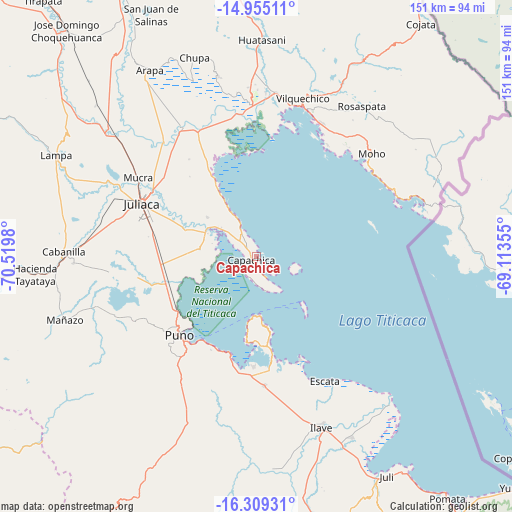
Capachica GPS coordinates[2]
15° 37' 59.988" South, 69° 49' 0.012" West
| Map corner | latitude | longitude |
|---|---|---|
| Upper-left | -14.95511°, | -70.5198° |
| Center: | -15.63333°, | -69.81667° |
| Lower-right: | -16.30931°, | -69.11355° |
| Map W x H: | 150.6×150.6 km | = 93.6×93.6mi |
| max Lat: | -0.96667° ⇑90.7% North |
| Capachica: | -15.63333° |
| min Lat: | ⇓9.3% South -18.01465° |
| min Long | Capachica | max Long |
| -81.30472° | -69.81667° | -69.04167° |
| W 97.4%⇐ | ⇒2.6% E |
Elevation
Elevation of Capachica is 3830 m = 12566 ft, and this is 1511.3 m = 4958 ft above average elevation for this country.
| Max E: |
5022 m = 16476 ft | 10.5% |
| Capachica | 3830 m 12566 ft | |
| Avg. | 2318.7 m = 7607 ft | |
Min E: |
1 m = 3 ft | 89.5% |
See also: Peru elevation on elevation.city.
Geographical zone
Capachica is located in South Torrid zone (between Equator and Tropic of Capricorn). Distance of this Southern Tropic circle is 867.7 km =539.2 mi to South.| Distance of | km | miles | from Capachica |
|---|---|---|---|
| Equator | 1738.3 | 1080.1 | to North |
| Tropic Capricorn | 867.7 | 539.2 | to South |
| Antarctic Circle | 5662.9 | 3518.8 | to South |
| South Pole | 8268.8 | 5138 | to South |


Nearby cities:
15 places around Capachica: (largest is in red/bold)
• Atuncolla
36.1 km =22.4 mi,  261°
261°
• Caminaca
44.2 km =27.5 mi,  322°
322°
• Caracoto
31.2 km =19.4 mi,  283°
283°
• Coata
16.1 km =10 mi,  297°
297°
• Conima
46.7 km =29 mi,  61°
61°
• Huata
16.2 km =10.1 mi, 276°
• Juliaca
37 km =23 mi,  293°
293°
• Moho
46.3 km =28.8 mi,  47°
47°
• Paucarcolla
27.3 km =17 mi,  246°
246°
• Puno
31.8 km =19.8 mi,  223°
223°
• Pusi
25.5 km =15.8 mi,  330°
330°
• Putina
44.7 km =27.8 mi,  66°
66°
• Taquile
20.6 km =12.8 mi,  136°
136°
• Taraco
40.4 km =25.1 mi,  336°
336°
• Tiquillaca
45.8 km =28.5 mi,  243°
243°
Sources, notices
• [Note1] Compared only with cities in Peru existing in our database
• [Src1] Map data: © OpenStreetMap contributors (CC-BY-SA)
• [Src2] Other city data from geonames.org with taken over terms of usage.
• [Src3] Geographical zone / Annual Mean Temperature by Robert A. Rohde @ Wikipedia
