Cahuanuyo geodata
Cahuanuyo (Cusco) is a populated place; located in Peru in America/Lima (GMT-5) time zone. With population of 3,935 people, there are 273 cities with bigger population in this country. Compared to other cities in Peru, 80.7% of cities are located further ↑North; 85.7% of cities are located further ←West and 91.4% of cities have lower elevation than Cahuanuyo. Note1


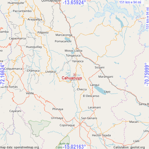
Cahuanuyo GPS coordinates[2]
14° 20' 29.292" South, 71° 27' 47.196" West
| Map corner | latitude | longitude |
|---|---|---|
| Upper-left | -13.65924°, | -72.16624° |
| Center: | -14.34147°, | -71.46311° |
| Lower-right: | -15.02163°, | -70.75999° |
| Map W x H: | 151.5×151.5 km | = 94.1×94.1mi |
| max Lat: | -0.96667° ⇑80.7% North |
| Cahuanuyo: | -14.34147° |
| min Lat: | ⇓19.3% South -18.01465° |
| min Long | Cahuanuyo | max Long |
| -81.30472° | -71.46311° | -69.04167° |
| W 85.7%⇐ | ⇒14.3% E |
Elevation
Elevation of Cahuanuyo is 3892 m = 12769 ft, and this is 1573.3 m = 5162 ft above average elevation for this country.
| Max E: |
5022 m = 16476 ft | 8.6% |
| Cahuanuyo | 3892 m 12769 ft | |
| Avg. | 2318.7 m = 7607 ft | |
Min E: |
1 m = 3 ft | 91.4% |
See also: Peru elevation on elevation.city.
Geographical zone
Cahuanuyo is located in South Torrid zone (between Equator and Tropic of Capricorn). Distance of this Southern Tropic circle is 1011.3 km =628.4 mi to South.| Distance of | km | miles | from Cahuanuyo |
|---|---|---|---|
| Equator | 1594.6 | 990.8 | to North |
| Tropic Capricorn | 1011.3 | 628.4 | to South |
| Antarctic Circle | 5806.6 | 3608.1 | to South |
| South Pole | 8412.4 | 5227.2 | to South |


Nearby cities:
15 places around Cahuanuyo: (largest is in red/bold)
• Ccaquiracunca
7.3 km =4.5 mi,  10°
10°
• Ccuntuma
24.6 km =15.3 mi, 12°
• Checca
16.4 km =10.2 mi,  152°
152°
• Chignayhua
10.8 km =6.7 mi, 10°
• Langui
22.8 km =14.2 mi,  116°
116°
• Livitaca
24.5 km =15.2 mi,  280°
280°
• Mosoc Llacta
24.6 km =15.3 mi,  357°
357°
• Pampamarca
21.7 km =13.5 mi,  1°
1°
• Quehue
4.4 km =2.7 mi,  168°
168°
• Queromarca
19.5 km =12.1 mi,  26°
26°
• San Pablo
22.1 km =13.7 mi,  45°
45°
• San Pedro
21.6 km =13.4 mi,  37°
37°
• Tinta
22.7 km =14.1 mi,  15°
15°
• Tungasuca
19.8 km =12.3 mi, 355°
• Yanaoca
14.1 km =8.8 mi, 13°
Sources, notices
• [Note1] Compared only with cities in Peru existing in our database
• [Src1] Map data: © OpenStreetMap contributors (CC-BY-SA)
• [Src2] Other city data from geonames.org with taken over terms of usage.
• [Src3] Geographical zone / Annual Mean Temperature by Robert A. Rohde @ Wikipedia
