Checca geodata
Checca (Cusco) is a seat of a third-order administrative division; located in Peru in America/Lima (GMT-5) time zone. With population of 3,810 people, there are 278 cities with bigger population in this country. Compared to other cities in Peru, 82.2% of cities are located further ↑North; 87.2% of cities are located further ←West and 88.9% of cities have lower elevation than Checca. Note1


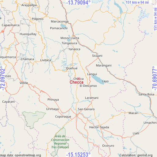
Checca GPS coordinates[2]
14° 28' 22.008" South, 71° 23' 38.004" West
| Map corner | latitude | longitude |
|---|---|---|
| Upper-left | -13.79094°, | -72.09702° |
| Center: | -14.47278°, | -71.39389° |
| Lower-right: | -15.15253°, | -70.69077° |
| Map W x H: | 151.4×151.4 km | = 94.1×94.1mi |
| max Lat: | -0.96667° ⇑82.2% North |
| Checca: | -14.47278° |
| min Lat: | ⇓17.8% South -18.01465° |
| min Long | Checca | max Long |
| -81.30472° | -71.39389° | -69.04167° |
| W 87.2%⇐ | ⇒12.8% E |
Elevation
Elevation of Checca is 3820 m = 12533 ft, and this is 1501.3 m = 4926 ft above average elevation for this country.
| Max E: |
5022 m = 16476 ft | 11.1% |
| Checca | 3820 m 12533 ft | |
| Avg. | 2318.7 m = 7607 ft | |
Min E: |
1 m = 3 ft | 88.9% |
See also: Peru elevation on elevation.city.
Geographical zone
Checca is located in South Torrid zone (between Equator and Tropic of Capricorn). Distance of this Southern Tropic circle is 996.7 km =619.3 mi to South.| Distance of | km | miles | from Checca |
|---|---|---|---|
| Equator | 1609.2 | 999.9 | to North |
| Tropic Capricorn | 996.7 | 619.3 | to South |
| Antarctic Circle | 5792 | 3599 | to South |
| South Pole | 8397.8 | 5218.1 | to South |


Nearby cities:
15 places around Checca: (largest is in red/bold)
• Cahuanuyo
16.4 km =10.2 mi,  332°
332°
• Ccaquiracunca
22.6 km =14 mi,  344°
344°
• Chignayhua
25.8 km =16 mi,  347°
347°
• Conchopata
21 km =13 mi,  89°
89°
• El Descanso
11.7 km =7.3 mi,  125°
125°
• Langui
13.8 km =8.6 mi,  70°
70°
• Layo
25.8 km =16 mi,  95°
95°
• Maranganí
27.4 km =17 mi,  61°
61°
• Pichigua
23.3 km =14.5 mi,  186°
186°
• Quehue
12.2 km =7.6 mi, 327°
• Queromarca
32.1 km =19.9 mi,  2°
2°
• San Pablo
31.2 km =19.4 mi,  15°
15°
• San Pedro
32.3 km =20.1 mi,  10°
10°
• Sicuani
28.9 km =18 mi,  38°
38°
• Yanaoca
28.6 km =17.8 mi, 351°
Sources, notices
• [Note1] Compared only with cities in Peru existing in our database
• [Src1] Map data: © OpenStreetMap contributors (CC-BY-SA)
• [Src2] Other city data from geonames.org with taken over terms of usage.
• [Src3] Geographical zone / Annual Mean Temperature by Robert A. Rohde @ Wikipedia
