Tungasuca geodata
Tungasuca (Cusco) is a seat of a third-order administrative division; located in Peru in America/Lima (GMT-5) time zone. With population of 3,791 people, there are 280 cities with bigger population in this country. Compared to other cities in Peru, 77.6% of cities are located further ↑North; 85.4% of cities are located further ←West and 87.8% of cities have lower elevation than Tungasuca. Note1


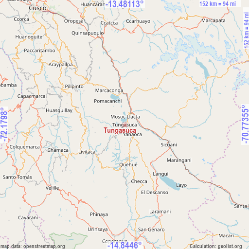
Tungasuca GPS coordinates[2]
14° 9' 50.004" South, 71° 28' 36.012" West
| Map corner | latitude | longitude |
|---|---|---|
| Upper-left | -13.48113°, | -72.1798° |
| Center: | -14.16389°, | -71.47667° |
| Lower-right: | -14.8446°, | -70.77355° |
| Map W x H: | 151.6×151.6 km | = 94.2×94.2mi |
| max Lat: | -0.96667° ⇑77.6% North |
| Tungasuca: | -14.16389° |
| min Lat: | ⇓22.4% South -18.01465° |
| min Long | Tungasuca | max Long |
| -81.30472° | -71.47667° | -69.04167° |
| W 85.4%⇐ | ⇒14.6% E |
Elevation
Elevation of Tungasuca is 3793 m = 12444 ft, and this is 1474.3 m = 4837 ft above average elevation for this country.
| Max E: |
5022 m = 16476 ft | 12.2% |
| Tungasuca | 3793 m 12444 ft | |
| Avg. | 2318.7 m = 7607 ft | |
Min E: |
1 m = 3 ft | 87.8% |
See also: Peru elevation on elevation.city.
Geographical zone
Tungasuca is located in South Torrid zone (between Equator and Tropic of Capricorn). Distance of this Southern Tropic circle is 1031 km =640.6 mi to South.| Distance of | km | miles | from Tungasuca |
|---|---|---|---|
| Equator | 1574.9 | 978.6 | to North |
| Tropic Capricorn | 1031 | 640.6 | to South |
| Antarctic Circle | 5826.3 | 3620.3 | to South |
| South Pole | 8432.2 | 5239.5 | to South |


Nearby cities:
15 places around Tungasuca: (largest is in red/bold)
• Ccaquiracunca
12.9 km =8 mi,  167°
167°
• Ccuntuma
8.2 km =5.1 mi,  58°
58°
• Checacupe
15.4 km =9.6 mi,  9°
9°
• Chignayhua
9.8 km =6.1 mi,  159°
159°
• Combapata
8.6 km =5.3 mi,  36°
36°
• Cullcuyre
17.6 km =10.9 mi, 63°
• Jayobamba
16.7 km =10.4 mi, 62°
• Lima Pampa
17.2 km =10.7 mi, 61°
• Mosoc Llacta
4.9 km =3 mi,  4°
4°
• Pampamarca
2.7 km =1.7 mi, 43°
• Qquea
15.6 km =9.7 mi, 38°
• Queromarca
10.3 km =6.4 mi,  102°
102°
• San Pedro
14.8 km =9.2 mi, 99°
• Tinta
7.8 km =4.8 mi,  74°
74°
• Yanaoca
7.7 km =4.8 mi,  141°
141°
Sources, notices
• [Note1] Compared only with cities in Peru existing in our database
• [Src1] Map data: © OpenStreetMap contributors (CC-BY-SA)
• [Src2] Other city data from geonames.org with taken over terms of usage.
• [Src3] Geographical zone / Annual Mean Temperature by Robert A. Rohde @ Wikipedia
