Viga geodata
Viga (Eastern Visayas) is a populated place; located in Philippines in Asia/Manila (GMT+8) time zone. With population of 2,024 people, there are 4149 cities with bigger population in this country. Compared to other cities in Philippines, 54.9% of cities are located further ↓South; 88.7% of cities are located further ←West and 80.7% of cities have higher elevation than Viga. Note1
Administrative division(s):
- Level 1: Eastern Visayas
- Level 2: Province of Northern Samar
- Level 3: Laoang


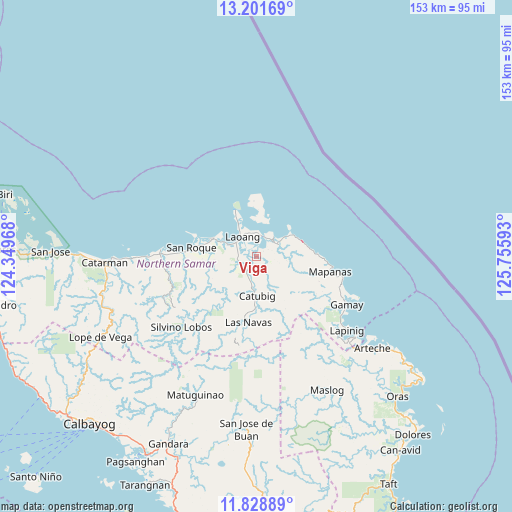
Viga GPS coordinates[2]
12° 30' 58.32" North, 125° 3' 10.08" East
| Map corner | latitude | longitude |
|---|---|---|
| Upper-left | 13.20169°, | 124.34968° |
| Center: | 12.5162°, | 125.0528° |
| Lower-right: | 11.82889°, | 125.75593° |
| Map W x H: | 152.6×152.6 km | = 94.8×94.8mi |
| max Lat: | 20.78733° ⇑45.1% North |
| Viga: | 12.5162° |
| min Lat: | ⇓54.9% South 4.65442° |
| min Long | Viga | max Long |
| 117.04868° | 125.0528° | 126.58417° |
| W 88.7%⇐ | ⇒11.3% E |
Elevation
Elevation of Viga is 9 m = 30 ft, and this is 78.9 m = 259 ft below average elevation for this country.
| Max E: |
2262 m = 7421 ft | 80.7% |
| Avg. | 87.9 m = 288 ft | |
| Viga | 9 m = 30 ft | |
Min E: |
-2 m = -7 ft | 19.3% |
See also: Philippines elevation on elevation.city.
Geographical zone
Viga is located in North Torrid zone (between Equator and Tropic of Cancer). Distance of this Northern Tropic circle is 1214.2 km =754.5 mi to North.| Distance of | km | miles | from Viga |
|---|---|---|---|
| North Pole | 8615.4 | 5353.4 | to North |
| Arctic Circle | 6009.5 | 3734.1 | to North |
| Tropic Cancer | 1214.2 | 754.5 | to North |
| Equator | 1391.7 | 864.8 | to South |


Nearby cities:
15 places around Viga: (largest is in red/bold)
• Anito
26.6 km =16.5 mi,  106°
106°
• Bantayan
24.4 km =15.2 mi,  271°
271°
• Bugko
28.4 km =17.6 mi, 274°
• Cabatuan
18.2 km =11.3 mi,  87°
87°
• Cabodiongan
16.5 km =10.3 mi,  357°
357°
• Catubig
11.8 km =7.3 mi,  178°
178°
• Laoang
7.3 km =4.5 mi,  324°
324°
• Las Navas
19.8 km =12.3 mi,  186°
186°
• Mapanas
22.6 km =14 mi,  101°
101°
• Nenita
27.1 km =16.8 mi,  264°
264°
• Palapag
7.5 km =4.7 mi,  63°
63°
• Pambujan
14.6 km =9.1 mi,  291°
291°
• Pangpang
6.3 km =3.9 mi,  21°
21°
• Salvacion
11.1 km =6.9 mi,  352°
352°
• San Roque
20.3 km =12.6 mi,  275°
275°
Sources, notices
• [Note1] Compared only with cities in Philippines existing in our database
• [Src1] Map data: © OpenStreetMap contributors (CC-BY-SA)
• [Src2] Other city data from geonames.org with taken over terms of usage.
• [Src3] Geographical zone / Annual Mean Temperature by Robert A. Rohde @ Wikipedia
