Palapag geodata
Palapag (Eastern Visayas) is a seat of a third-order administrative division; located in Philippines in Asia/Manila (GMT+8) time zone. With population of 8,342 people, there are 739 cities with bigger population in this country. Compared to other cities in Philippines, 55.2% of cities are located further ↓South; 89.3% of cities are located further ←West and 70.2% of cities have higher elevation than Palapag. Note1
Administrative division(s):
- Level 1: Eastern Visayas
- Level 2: Province of Northern Samar
- Level 3: Palapag


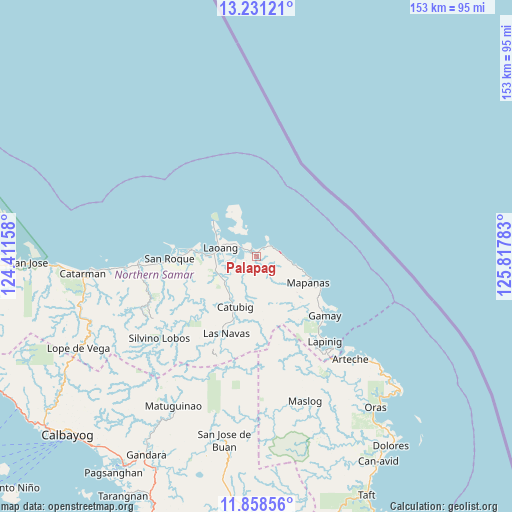
Palapag GPS coordinates[2]
12° 32' 44.88" North, 125° 6' 52.92" East
| Map corner | latitude | longitude |
|---|---|---|
| Upper-left | 13.23121°, | 124.41158° |
| Center: | 12.5458°, | 125.1147° |
| Lower-right: | 11.85856°, | 125.81783° |
| Map W x H: | 152.6×152.6 km | = 94.8×94.8mi |
| max Lat: | 20.78733° ⇑44.8% North |
| Palapag: | 12.5458° |
| min Lat: | ⇓55.2% South 4.65442° |
| min Long | Palapag | max Long |
| 117.04868° | 125.1147° | 126.58417° |
| W 89.3%⇐ | ⇒10.7% E |
Elevation
Elevation of Palapag is 12 m = 39 ft, and this is 75.9 m = 249 ft below average elevation for this country.
| Max E: |
2262 m = 7421 ft | 70.2% |
| Avg. | 87.9 m = 288 ft | |
| Palapag | 12 m = 39 ft | |
Min E: |
-2 m = -7 ft | 29.8% |
See also: Philippines elevation on elevation.city.
Geographical zone
Palapag is located in North Torrid zone (between Equator and Tropic of Cancer). Distance of this Northern Tropic circle is 1211 km =752.5 mi to North.| Distance of | km | miles | from Palapag |
|---|---|---|---|
| North Pole | 8612.1 | 5351.3 | to North |
| Arctic Circle | 6006.2 | 3732.1 | to North |
| Tropic Cancer | 1211 | 752.5 | to North |
| Equator | 1395 | 866.8 | to South |


Nearby cities:
15 places around Palapag: (largest is in red/bold)
• Anito
21.7 km =13.5 mi,  119°
119°
• Cabatuan
11.7 km =7.3 mi,  102°
102°
• Cabodiongan
15.2 km =9.4 mi,  330°
330°
• Cagamotan
28 km =17.4 mi,  138°
138°
• Catubig
16.5 km =10.3 mi,  203°
203°
• Gamay
26.7 km =16.6 mi,  131°
131°
• Laoang
11.2 km =7 mi,  283°
283°
• Las Navas
24.7 km =15.3 mi, 201°
• Mapanas
17.3 km =10.7 mi, 117°
• Pambujan
20.4 km =12.7 mi, 275°
• Pangpang
5.1 km =3.2 mi,  300°
300°
• Patong
29.7 km =18.5 mi, 141°
• Salvacion
11.3 km =7 mi,  313°
313°
• San Roque
27 km =16.8 mi,  267°
267°
• Viga
7.5 km =4.7 mi,  243°
243°
Sources, notices
• [Note1] Compared only with cities in Philippines existing in our database
• [Src1] Map data: © OpenStreetMap contributors (CC-BY-SA)
• [Src2] Other city data from geonames.org with taken over terms of usage.
• [Src3] Geographical zone / Annual Mean Temperature by Robert A. Rohde @ Wikipedia
