Catubig geodata
Catubig (Eastern Visayas) is a seat of a third-order administrative division; located in Philippines in Asia/Manila (GMT+8) time zone. With population of 4,728 people, there are 1401 cities with bigger population in this country. Compared to other cities in Philippines, 54.2% of cities are located further ↓South; 88.8% of cities are located further ←West and 97.1% of cities have higher elevation than Catubig. Note1
Administrative division(s):
- Level 1: Eastern Visayas
- Level 2: Province of Northern Samar
- Level 3: Catubig


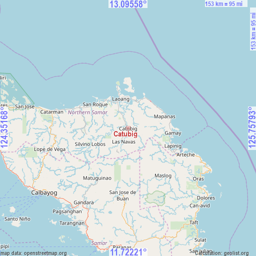
Catubig GPS coordinates[2]
12° 24' 35.28" North, 125° 3' 17.28" East
| Map corner | latitude | longitude |
|---|---|---|
| Upper-left | 13.09558°, | 124.35168° |
| Center: | 12.4098°, | 125.0548° |
| Lower-right: | 11.72221°, | 125.75793° |
| Map W x H: | 152.7×152.7 km | = 94.9×94.9mi |
| max Lat: | 20.78733° ⇑45.8% North |
| Catubig: | 12.4098° |
| min Lat: | ⇓54.2% South 4.65442° |
| min Long | Catubig | max Long |
| 117.04868° | 125.0548° | 126.58417° |
| W 88.8%⇐ | ⇒11.2% E |
Elevation
Elevation of Catubig is 4 m = 13 ft, and this is 83.9 m = 275 ft below average elevation for this country.
| Max E: |
2262 m = 7421 ft | 97.1% |
| Avg. | 87.9 m = 288 ft | |
| Catubig | 4 m = 13 ft | |
Min E: |
-2 m = -7 ft | 2.9% |
See also: Philippines elevation on elevation.city.
Geographical zone
Catubig is located in North Torrid zone (between Equator and Tropic of Cancer). Distance of this Northern Tropic circle is 1226.1 km =761.9 mi to North.| Distance of | km | miles | from Catubig |
|---|---|---|---|
| North Pole | 8627.2 | 5360.7 | to North |
| Arctic Circle | 6021.3 | 3741.5 | to North |
| Tropic Cancer | 1226.1 | 761.9 | to North |
| Equator | 1379.8 | 857.4 | to South |


Nearby cities:
15 places around Catubig: (largest is in red/bold)
• Anito
25.8 km =16 mi,  80°
80°
• Cabatuan
21.9 km =13.6 mi,  55°
55°
• Cagamotan
25.6 km =15.9 mi,  103°
103°
• Gamay
26.5 km =16.5 mi, 95°
• Hipadpad
24.1 km =15 mi,  125°
125°
• Laoang
18.3 km =11.4 mi,  346°
346°
• Las Navas
8.3 km =5.2 mi,  198°
198°
• Mapanas
23 km =14.3 mi,  71°
71°
• Palapag
16.5 km =10.3 mi,  23°
23°
• Pambujan
22 km =13.7 mi,  321°
321°
• Pangpang
17.8 km =11.1 mi,  6°
6°
• Patong
26.3 km =16.3 mi,  108°
108°
• Salvacion
22.9 km =14.2 mi,  355°
355°
• San Roque
24.6 km =15.3 mi,  303°
303°
• Viga
11.8 km =7.3 mi, 358°
Sources, notices
• [Note1] Compared only with cities in Philippines existing in our database
• [Src1] Map data: © OpenStreetMap contributors (CC-BY-SA)
• [Src2] Other city data from geonames.org with taken over terms of usage.
• [Src3] Geographical zone / Annual Mean Temperature by Robert A. Rohde @ Wikipedia
