Valenzuela geodata
Valenzuela (Metro Manila) is a seat of a third-order administrative division; located in Philippines in Asia/Manila (GMT+8) time zone. In our database, there are 4166 cities with bigger population. Compared to other cities in Philippines, 75.2% of cities are located further ↓South; 77.2% of cities are located further →East and 70.2% of cities have higher elevation than Valenzuela. Note1
Administrative division(s):
- Level 1: Metro Manila
- Level 2: Northern Manila District
- Level 3: City of Valenzuela


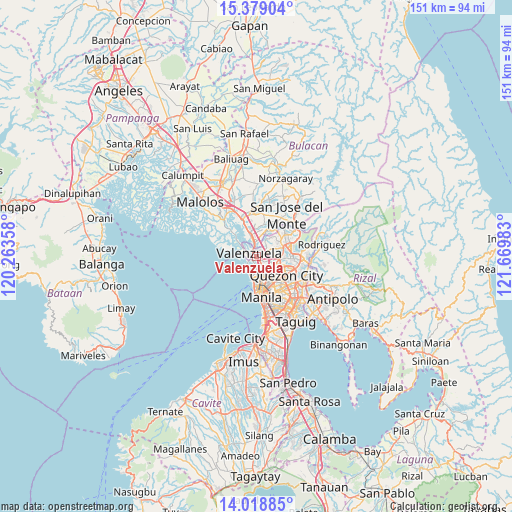
Valenzuela GPS coordinates[2]
14° 42' 0" North, 120° 58' 0.12" East
| Map corner | latitude | longitude |
|---|---|---|
| Upper-left | 15.37904°, | 120.26358° |
| Center: | 14.7°, | 120.9667° |
| Lower-right: | 14.01885°, | 121.66983° |
| Map W x H: | 151.2×151.2 km | = 94×94mi |
| max Lat: | 20.78733° ⇑24.8% North |
| Valenzuela: | 14.7° |
| min Lat: | ⇓75.2% South 4.65442° |
| min Long | Valenzuela | max Long |
| 117.04868° | 120.9667° | 126.58417° |
| W 22.8%⇐ | ⇒77.2% E |
Elevation
Elevation of Valenzuela is 12 m = 39 ft, and this is 75.9 m = 249 ft below average elevation for this country.
| Max E: |
2262 m = 7421 ft | 70.2% |
| Avg. | 87.9 m = 288 ft | |
| Valenzuela | 12 m = 39 ft | |
Min E: |
-2 m = -7 ft | 29.8% |
See also: Philippines elevation on elevation.city.
Geographical zone
Valenzuela is located in North Torrid zone (between Equator and Tropic of Cancer). Distance of this Northern Tropic circle is 971.4 km =603.6 mi to North.| Distance of | km | miles | from Valenzuela |
|---|---|---|---|
| North Pole | 8372.6 | 5202.5 | to North |
| Arctic Circle | 5766.7 | 3583.3 | to North |
| Tropic Cancer | 971.4 | 603.6 | to North |
| Equator | 1634.5 | 1015.6 | to South |


Nearby cities:
15 places around Valenzuela: (largest is in red/bold)
• Bagong Pagasa
8.2 km =5.1 mi,  120°
120°
• Caloocan City
5.6 km =3.5 mi,  178°
178°
• Del Monte
8.5 km =5.3 mi,  139°
139°
• Loma de Gato
10.5 km =6.5 mi,  19°
19°
• Malabon
4.1 km =2.5 mi,  224°
224°
• Manila
10.8 km =6.7 mi,  171°
171°
• Marilao
6.7 km =4.2 mi,  342°
342°
• Meycauayan
4.2 km =2.6 mi,  351°
351°
• Navotas
4.1 km =2.5 mi,  205°
205°
• Niugan
4.1 km =2.5 mi,  197°
197°
• Obando
3.5 km =2.2 mi,  288°
288°
• Quezon City
10.7 km =6.6 mi, 122°
• Quiapo
11.3 km =7 mi, 170°
• Sulucan
11.4 km =7.1 mi, 337°
• Tanza
4.1 km =2.5 mi,  227°
227°
Sources, notices
• [Note1] Compared only with cities in Philippines existing in our database
• [Src1] Map data: © OpenStreetMap contributors (CC-BY-SA)
• [Src2] Other city data from geonames.org with taken over terms of usage.
• [Src3] Geographical zone / Annual Mean Temperature by Robert A. Rohde @ Wikipedia
