Loma de Gato geodata
Loma de Gato (Central Luzon) is a populated place; located in Philippines in Asia/Manila (GMT+8) time zone. With population of 21,990 people, there are 350 cities with bigger population in this country. Compared to other cities in Philippines, 75.6% of cities are located further ↓South; 76.4% of cities are located further →East and 67.5% of cities have lower elevation than Loma de Gato. Note1


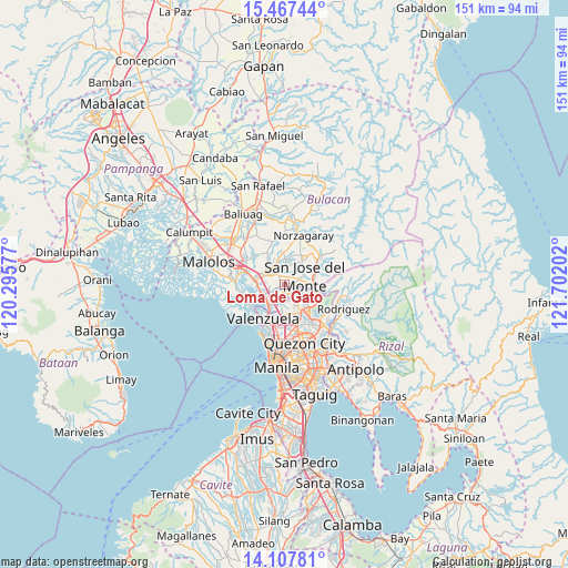
Loma de Gato GPS coordinates[2]
14° 47' 19.284" North, 120° 59' 56.004" East
| Map corner | latitude | longitude |
|---|---|---|
| Upper-left | 15.46744°, | 120.29577° |
| Center: | 14.78869°, | 120.99889° |
| Lower-right: | 14.10781°, | 121.70202° |
| Map W x H: | 151.2×151.2 km | = 94×94mi |
| max Lat: | 20.78733° ⇑24.4% North |
| Loma de Gato: | 14.78869° |
| min Lat: | ⇓75.6% South 4.65442° |
| min Long | Loma de Gato | max Long |
| 117.04868° | 120.99889° | 126.58417° |
| W 23.6%⇐ | ⇒76.4% E |
Elevation
Elevation of Loma de Gato is 47 m = 154 ft, and this is 40.9 m = 134 ft below average elevation for this country.
| Max E: |
2262 m = 7421 ft | 32.5% |
| Avg. | 87.9 m = 288 ft | |
| Loma de Gato | 47 m = 154 ft | |
Min E: |
-2 m = -7 ft | 67.5% |
See also: Philippines elevation on elevation.city.
Geographical zone
Loma de Gato is located in North Torrid zone (between Equator and Tropic of Cancer). Distance of this Northern Tropic circle is 961.6 km =597.5 mi to North.| Distance of | km | miles | from Loma de Gato |
|---|---|---|---|
| North Pole | 8362.7 | 5196.3 | to North |
| Arctic Circle | 5756.8 | 3577.1 | to North |
| Tropic Cancer | 961.6 | 597.5 | to North |
| Equator | 1644.3 | 1021.7 | to South |


Nearby cities:
15 places around Loma de Gato: (largest is in red/bold)
• Angat
12.9 km =8 mi,  272°
272°
• Bagong Barrio
12.9 km =8 mi,  331°
331°
• Balasing
7.5 km =4.7 mi,  11°
11°
• Bituñgol
11.2 km =7 mi,  19°
19°
• Bocaue
7.9 km =4.9 mi,  277°
277°
• Guyong
5.7 km =3.5 mi,  337°
337°
• Marilao
6.4 km =4 mi,  237°
237°
• Meycauayan
7.1 km =4.4 mi,  215°
215°
• Obando
11.1 km =6.9 mi, 217°
• Pandi
9.6 km =6 mi, 332°
• Pulong Gubat
12.7 km =7.9 mi,  308°
308°
• San Jose del Monte
5.7 km =3.5 mi,  60°
60°
• Santa Maria
5.2 km =3.2 mi, 313°
• Sulucan
7.9 km =4.9 mi, 274°
• Valenzuela
10.5 km =6.5 mi,  199°
199°
Sources, notices
• [Note1] Compared only with cities in Philippines existing in our database
• [Src1] Map data: © OpenStreetMap contributors (CC-BY-SA)
• [Src2] Other city data from geonames.org with taken over terms of usage.
• [Src3] Geographical zone / Annual Mean Temperature by Robert A. Rohde @ Wikipedia
