Valderrama geodata
Valderrama (Western Visayas) is a populated place; located in Philippines in Asia/Manila (GMT+8) time zone. With population of 4,276 people, there are 1596 cities with bigger population in this country. Compared to other cities in Philippines, 52.5% of cities are located further ↑North; 59.2% of cities are located further →East and 58.1% of cities have lower elevation than Valderrama. Note1


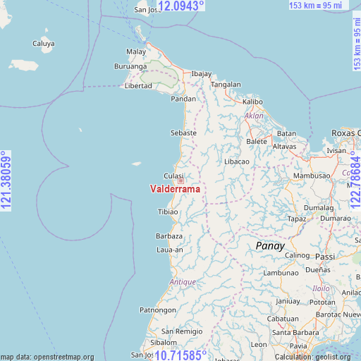
Valderrama GPS coordinates[2]
11° 24' 21.276" North, 122° 5' 1.356" East
| Map corner | latitude | longitude |
|---|---|---|
| Upper-left | 12.0943°, | 121.38059° |
| Center: | 11.40591°, | 122.08371° |
| Lower-right: | 10.71585°, | 122.78684° |
| Map W x H: | 153.3×153.3 km | = 95.3×95.3mi |
| max Lat: | 20.78733° ⇑52.5% North |
| Valderrama: | 11.40591° |
| min Lat: | ⇓47.5% South 4.65442° |
| min Long | Valderrama | max Long |
| 117.04868° | 122.08371° | 126.58417° |
| W 40.8%⇐ | ⇒59.2% E |
Elevation
Elevation of Valderrama is 31 m = 102 ft, and this is 56.9 m = 187 ft below average elevation for this country.
| Max E: |
2262 m = 7421 ft | 41.9% |
| Avg. | 87.9 m = 288 ft | |
| Valderrama | 31 m = 102 ft | |
Min E: |
-2 m = -7 ft | 58.1% |
See also: Philippines elevation on elevation.city.
Geographical zone
Valderrama is located in North Torrid zone (between Equator and Tropic of Cancer). Distance of Equator is 1268.2 km =788 mi to South.| Distance of | km | miles | from Valderrama |
|---|---|---|---|
| North Pole | 8738.8 | 5430 | to North |
| Arctic Circle | 6133 | 3810.9 | to North |
| Tropic Cancer | 1337.7 | 831.2 | to North |
| Equator | 1268.2 | 788 | to South |


Nearby cities:
15 places around Valderrama: (largest is in red/bold)
• Abiera
18.8 km =11.7 mi,  2°
2°
• Bacalan
15.6 km =9.7 mi, 0°
• Barbaza
23.9 km =14.9 mi,  191°
191°
• Bitadtun
10.1 km =6.3 mi, 0°
• Culasi
3.8 km =2.4 mi,  308°
308°
• Idio
24.3 km =15.1 mi, 3°
• Lawa-an
29 km =18 mi, 190°
• Libacao
25.4 km =15.8 mi,  71°
71°
• Madalag
27.8 km =17.3 mi,  61°
61°
• Malabor
15.3 km =9.5 mi,  195°
195°
• Manika
21.4 km =13.3 mi,  95°
95°
• Rosario
30.9 km =19.2 mi,  50°
50°
• San Francisco
10.3 km =6.4 mi, 200°
• Sebaste
20.5 km =12.7 mi, 3°
• Tibiao
13.8 km =8.6 mi, 202°
Sources, notices
• [Note1] Compared only with cities in Philippines existing in our database
• [Src1] Map data: © OpenStreetMap contributors (CC-BY-SA)
• [Src2] Other city data from geonames.org with taken over terms of usage.
• [Src3] Geographical zone / Annual Mean Temperature by Robert A. Rohde @ Wikipedia
