Manika geodata
Manika (Western Visayas) is a populated place; located in Philippines in Asia/Manila (GMT+8) time zone. With population of 3,074 people, there are 2444 cities with bigger population in this country. Compared to other cities in Philippines, 52.6% of cities are located further ↑North; 57.4% of cities are located further →East and 81.8% of cities have lower elevation than Manika. Note1


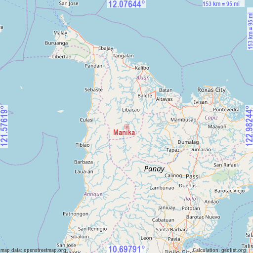
Manika GPS coordinates[2]
11° 23' 16.836" North, 122° 16' 45.516" East
| Map corner | latitude | longitude |
|---|---|---|
| Upper-left | 12.07644°, | 121.57619° |
| Center: | 11.38801°, | 122.27931° |
| Lower-right: | 10.69791°, | 122.98244° |
| Map W x H: | 153.3×153.3 km | = 95.3×95.3mi |
| max Lat: | 20.78733° ⇑52.6% North |
| Manika: | 11.38801° |
| min Lat: | ⇓47.4% South 4.65442° |
| min Long | Manika | max Long |
| 117.04868° | 122.27931° | 126.58417° |
| W 42.6%⇐ | ⇒57.4% E |
Elevation
Elevation of Manika is 105 m = 344 ft, and this is 17.1 m = 56 ft above average elevation for this country.
| Max E: |
2262 m = 7421 ft | 18.2% |
| Manika | 105 m 344 ft | |
| Avg. | 87.9 m = 288 ft | |
Min E: |
-2 m = -7 ft | 81.8% |
See also: Philippines elevation on elevation.city.
Geographical zone
Manika is located in North Torrid zone (between Equator and Tropic of Cancer). Distance of Equator is 1266.2 km =786.8 mi to South.| Distance of | km | miles | from Manika |
|---|---|---|---|
| North Pole | 8740.8 | 5431.3 | to North |
| Arctic Circle | 6134.9 | 3812 | to North |
| Tropic Cancer | 1339.7 | 832.5 | to North |
| Equator | 1266.2 | 786.8 | to South |


Nearby cities:
15 places around Manika: (largest is in red/bold)
• Aranas Sur
22.9 km =14.2 mi,  31°
31°
• Arcangel
18.3 km =11.4 mi,  23°
23°
• Balete
21.6 km =13.4 mi, 30°
• Cortez
20.4 km =12.7 mi,  39°
39°
• Da-an Sur
20.9 km =13 mi,  132°
132°
• Feliciano
22.9 km =14.2 mi, 22°
• Jaena
13.5 km =8.4 mi,  76°
76°
• Jamindan
23.9 km =14.9 mi,  86°
86°
• Libacao
10.6 km =6.6 mi,  14°
14°
• Lucero
21.5 km =13.4 mi,  69°
69°
• Madalag
15.8 km =9.8 mi, 11°
• Morales
20.5 km =12.7 mi, 31°
• Polo
22.1 km =13.7 mi, 9°
• Rosario
21.8 km =13.5 mi, 6°
• Valderrama
21.4 km =13.3 mi,  275°
275°
Sources, notices
• [Note1] Compared only with cities in Philippines existing in our database
• [Src1] Map data: © OpenStreetMap contributors (CC-BY-SA)
• [Src2] Other city data from geonames.org with taken over terms of usage.
• [Src3] Geographical zone / Annual Mean Temperature by Robert A. Rohde @ Wikipedia
