Lawa-an geodata
Lawa-an (Western Visayas) is a seat of a third-order administrative division; located in Philippines in Asia/Manila (GMT+8) time zone. In our database, there are 4166 cities with bigger population. Compared to other cities in Philippines, 55.1% of cities are located further ↑North; 59.7% of cities are located further →East and 80.7% of cities have higher elevation than Lawa-an. Note1


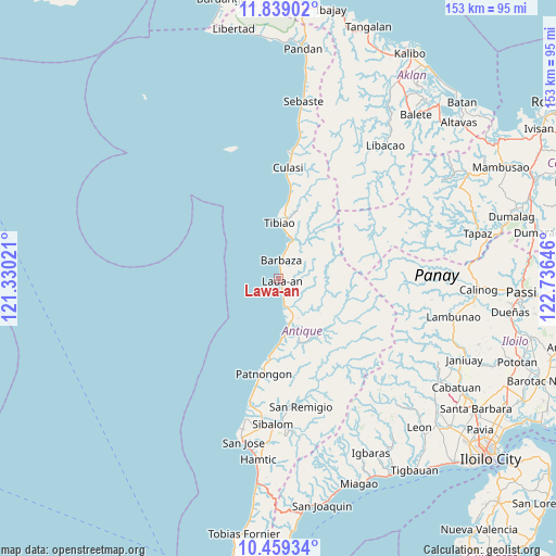
Lawa-an GPS coordinates[2]
11° 9' 0" North, 122° 1' 59.988" East
| Map corner | latitude | longitude |
|---|---|---|
| Upper-left | 11.83902°, | 121.33021° |
| Center: | 11.15°, | 122.03333° |
| Lower-right: | 10.45934°, | 122.73646° |
| Map W x H: | 153.4×153.4 km | = 95.3×95.3mi |
| max Lat: | 20.78733° ⇑55.1% North |
| Lawa-an: | 11.15° |
| min Lat: | ⇓44.9% South 4.65442° |
| min Long | Lawa-an | max Long |
| 117.04868° | 122.03333° | 126.58417° |
| W 40.3%⇐ | ⇒59.7% E |
Elevation
Elevation of Lawa-an is 9 m = 30 ft, and this is 78.9 m = 259 ft below average elevation for this country.
| Max E: |
2262 m = 7421 ft | 80.7% |
| Avg. | 87.9 m = 288 ft | |
| Lawa-an | 9 m = 30 ft | |
Min E: |
-2 m = -7 ft | 19.3% |
See also: Philippines elevation on elevation.city.
Geographical zone
Lawa-an is located in North Torrid zone (between Equator and Tropic of Cancer). Distance of Equator is 1239.8 km =770.4 mi to South.| Distance of | km | miles | from Lawa-an |
|---|---|---|---|
| North Pole | 8767.3 | 5447.7 | to North |
| Arctic Circle | 6161.4 | 3828.5 | to North |
| Tropic Cancer | 1366.2 | 848.9 | to North |
| Equator | 1239.8 | 770.4 | to South |


Nearby cities:
15 places around Lawa-an: (largest is in red/bold)
• Aurelliana
30.1 km =18.7 mi,  191°
191°
• Barbaza
5.1 km =3.2 mi,  6°
6°
• Belison
35.5 km =22.1 mi, 192°
• Bitadtun
39 km =24.2 mi, 8°
• Bugasong
12.2 km =7.6 mi,  163°
163°
• Culasi
30.9 km =19.2 mi,  4°
4°
• Guisijan
6.5 km =4 mi,  167°
167°
• Jayubó
39.8 km =24.7 mi,  106°
106°
• Malabor
13.7 km =8.5 mi, 6°
• Manika
37.7 km =23.4 mi,  45°
45°
• Patnongon
26.7 km =16.6 mi, 189°
• San Francisco
19 km =11.8 mi, 5°
• San Remigio
35.8 km =22.2 mi, 170°
• Tibiao
15.7 km =9.8 mi, 0°
• Valderrama
29 km =18 mi, 10°
Sources, notices
• [Note1] Compared only with cities in Philippines existing in our database
• [Src1] Map data: © OpenStreetMap contributors (CC-BY-SA)
• [Src2] Other city data from geonames.org with taken over terms of usage.
• [Src3] Geographical zone / Annual Mean Temperature by Robert A. Rohde @ Wikipedia
