Upi geodata
Upi (Cagayan Valley) is a populated place; located in Philippines in Asia/Manila (GMT+8) time zone. With population of 5,647 people, there are 1128 cities with bigger population in this country. Compared to other cities in Philippines, 93.9% of cities are located further ↓South; 62.2% of cities are located further →East and 68% of cities have lower elevation than Upi. Note1


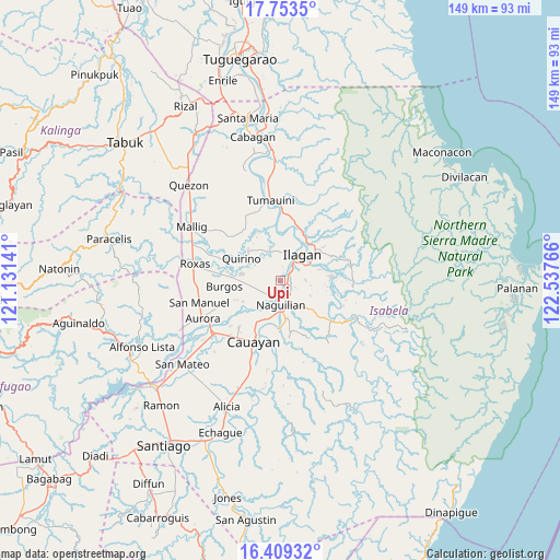
Upi GPS coordinates[2]
17° 4' 57.432" North, 121° 50' 4.308" East
| Map corner | latitude | longitude |
|---|---|---|
| Upper-left | 17.7535°, | 121.13141° |
| Center: | 17.08262°, | 121.83453° |
| Lower-right: | 16.40932°, | 122.53766° |
| Map W x H: | 149.5×149.5 km | = 92.9×92.9mi |
| max Lat: | 20.78733° ⇑6.1% North |
| Upi: | 17.08262° |
| min Lat: | ⇓93.9% South 4.65442° |
| min Long | Upi | max Long |
| 117.04868° | 121.83453° | 126.58417° |
| W 37.8%⇐ | ⇒62.2% E |
Elevation
Elevation of Upi is 48 m = 157 ft, and this is 39.9 m = 131 ft below average elevation for this country.
| Max E: |
2262 m = 7421 ft | 32% |
| Avg. | 87.9 m = 288 ft | |
| Upi | 48 m = 157 ft | |
Min E: |
-2 m = -7 ft | 68% |
See also: Philippines elevation on elevation.city.
Geographical zone
Upi is located in North Torrid zone (between Equator and Tropic of Cancer). Distance of this Northern Tropic circle is 706.5 km =439 mi to North.| Distance of | km | miles | from Upi |
|---|---|---|---|
| North Pole | 8107.7 | 5037.9 | to North |
| Arctic Circle | 5501.8 | 3418.7 | to North |
| Tropic Cancer | 706.5 | 439 | to North |
| Equator | 1899.4 | 1180.2 | to South |


Nearby cities:
15 places around Upi: (largest is in red/bold)
• Alibago
5.1 km =3.2 mi,  42°
42°
• Banquero
8.9 km =5.5 mi,  222°
222°
• Cabannungan Second
5 km =3.1 mi,  19°
19°
• Furao
6.7 km =4.2 mi, 216°
• Gamu
3.7 km =2.3 mi,  177°
177°
• Ilagan
9.4 km =5.8 mi, 38°
• Mabini
10.8 km =6.7 mi,  279°
279°
• Manaring
12.4 km =7.7 mi, 35°
• Minallo
10.8 km =6.7 mi,  169°
169°
• Naguilian
6.6 km =4.1 mi, 177°
• Reina Mercedes
10.8 km =6.7 mi, 184°
• San Luis
13.1 km =8.1 mi, 183°
• San Mateo
11.3 km =7 mi,  302°
302°
• Santo Domingo
12.3 km =7.6 mi,  314°
314°
• Yeban Norte
13.3 km =8.3 mi,  120°
120°
Sources, notices
• [Note1] Compared only with cities in Philippines existing in our database
• [Src1] Map data: © OpenStreetMap contributors (CC-BY-SA)
• [Src2] Other city data from geonames.org with taken over terms of usage.
• [Src3] Geographical zone / Annual Mean Temperature by Robert A. Rohde @ Wikipedia
