Manaring geodata
Manaring (Cagayan Valley) is a populated place; located in Philippines in Asia/Manila (GMT+8) time zone. With population of 2,114 people, there are 4051 cities with bigger population in this country. Compared to other cities in Philippines, 94.6% of cities are located further ↓South; 61.6% of cities are located further →East and 72.2% of cities have lower elevation than Manaring. Note1
Administrative division(s):
- Level 1: Cagayan Valley
- Level 2: Province of Isabela
- Level 3: Ilagan City


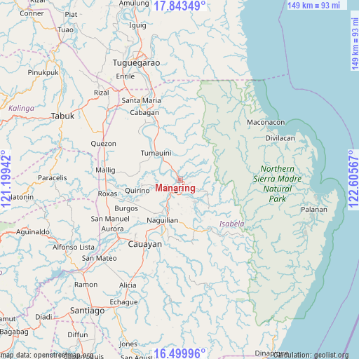
Manaring GPS coordinates[2]
17° 10' 22.584" North, 121° 54' 9.144" East
| Map corner | latitude | longitude |
|---|---|---|
| Upper-left | 17.84349°, | 121.19942° |
| Center: | 17.17294°, | 121.90254° |
| Lower-right: | 16.49996°, | 122.60567° |
| Map W x H: | 149.4×149.4 km | = 92.8×92.8mi |
| max Lat: | 20.78733° ⇑5.4% North |
| Manaring: | 17.17294° |
| min Lat: | ⇓94.6% South 4.65442° |
| min Long | Manaring | max Long |
| 117.04868° | 121.90254° | 126.58417° |
| W 38.4%⇐ | ⇒61.6% E |
Elevation
Elevation of Manaring is 58 m = 190 ft, and this is 29.9 m = 98 ft below average elevation for this country.
| Max E: |
2262 m = 7421 ft | 27.8% |
| Avg. | 87.9 m = 288 ft | |
| Manaring | 58 m = 190 ft | |
Min E: |
-2 m = -7 ft | 72.2% |
See also: Philippines elevation on elevation.city.
Geographical zone
Manaring is located in North Torrid zone (between Equator and Tropic of Cancer). Distance of this Northern Tropic circle is 696.5 km =432.8 mi to North.| Distance of | km | miles | from Manaring |
|---|---|---|---|
| North Pole | 8097.6 | 5031.6 | to North |
| Arctic Circle | 5491.7 | 3412.4 | to North |
| Tropic Cancer | 696.5 | 432.8 | to North |
| Equator | 1909.5 | 1186.5 | to South |


Nearby cities:
15 places around Manaring: (largest is in red/bold)
• Alibago
7.3 km =4.5 mi,  211°
211°
• Antagan Segunda
12.6 km =7.8 mi,  344°
344°
• Cabannungan Second
7.7 km =4.8 mi,  225°
225°
• Gamu
15.4 km =9.6 mi, 207°
• Ganapi
5.1 km =3.2 mi,  308°
308°
• Ilagan
3.1 km =1.9 mi, 207°
• Naguilian
18.1 km =11.2 mi,  202°
202°
• San Antonio
16.3 km =10.1 mi, 313°
• San Mateo
17.2 km =10.7 mi,  256°
256°
• San Pedro
3.6 km =2.2 mi,  325°
325°
• Santo Domingo
16.1 km =10 mi, 264°
• Sindon
17.3 km =10.7 mi,  136°
136°
• Tumauini
15.3 km =9.5 mi,  319°
319°
• Upi
12.4 km =7.7 mi,  215°
215°
• Yeban Norte
17.3 km =10.7 mi,  165°
165°
Sources, notices
• [Note1] Compared only with cities in Philippines existing in our database
• [Src1] Map data: © OpenStreetMap contributors (CC-BY-SA)
• [Src2] Other city data from geonames.org with taken over terms of usage.
• [Src3] Geographical zone / Annual Mean Temperature by Robert A. Rohde @ Wikipedia
