Ungca geodata
Ungca (Western Visayas) is a populated place; located in Philippines in Asia/Manila (GMT+8) time zone. With population of 5,599 people, there are 1133 cities with bigger population in this country. Compared to other cities in Philippines, 60.2% of cities are located further ↑North; 53.7% of cities are located further →East and 76.6% of cities have higher elevation than Ungca. Note1
Administrative division(s):
- Level 1: Western Visayas
- Level 2: Province of Iloilo
- Level 3: Iloilo City


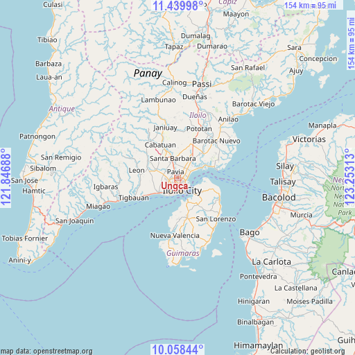
Ungca GPS coordinates[2]
10° 45' 0" North, 122° 33' 0" East
| Map corner | latitude | longitude |
|---|---|---|
| Upper-left | 11.43998°, | 121.84688° |
| Center: | 10.75°, | 122.55° |
| Lower-right: | 10.05844°, | 123.25313° |
| Map W x H: | 153.6×153.6 km | = 95.4×95.4mi |
| max Lat: | 20.78733° ⇑60.2% North |
| Ungca: | 10.75° |
| min Lat: | ⇓39.8% South 4.65442° |
| min Long | Ungca | max Long |
| 117.04868° | 122.55° | 126.58417° |
| W 46.3%⇐ | ⇒53.7% E |
Elevation
Elevation of Ungca is 10 m = 33 ft, and this is 77.9 m = 256 ft below average elevation for this country.
| Max E: |
2262 m = 7421 ft | 76.6% |
| Avg. | 87.9 m = 288 ft | |
| Ungca | 10 m = 33 ft | |
Min E: |
-2 m = -7 ft | 23.4% |
See also: Philippines elevation on elevation.city.
Geographical zone
Ungca is located in North Torrid zone (between Equator and Tropic of Cancer). Distance of Equator is 1195.3 km =742.7 mi to South.| Distance of | km | miles | from Ungca |
|---|---|---|---|
| North Pole | 8811.8 | 5475.4 | to North |
| Arctic Circle | 6205.9 | 3856.2 | to North |
| Tropic Cancer | 1410.6 | 876.5 | to North |
| Equator | 1195.3 | 742.7 | to South |


Nearby cities:
15 places around Ungca: (largest is in red/bold)
• Abilay
5.8 km =3.6 mi,  251°
251°
• Aganan
4.1 km =2.5 mi,  333°
333°
• Balabag
6.4 km =4 mi,  283°
283°
• Balibagan Oeste
6.6 km =4.1 mi, 326°
• Bolong
8.3 km =5.2 mi, 333°
• Cabugao
6.7 km =4.2 mi,  355°
355°
• Cagbang
7.9 km =4.9 mi,  225°
225°
• Iloilo
6.1 km =3.8 mi,  165°
165°
• Jibao-an
6.6 km =4.1 mi,  304°
304°
• Leganes
6 km =3.7 mi,  45°
45°
• Pakiad
5 km =3.1 mi,  214°
214°
• Pavia
2.9 km =1.8 mi,  350°
350°
• San Jose
2.9 km =1.8 mi,  322°
322°
• Santa Barbara
8.3 km =5.2 mi, 348°
• Tigum
4.1 km =2.5 mi,  26°
26°
Sources, notices
• [Note1] Compared only with cities in Philippines existing in our database
• [Src1] Map data: © OpenStreetMap contributors (CC-BY-SA)
• [Src2] Other city data from geonames.org with taken over terms of usage.
• [Src3] Geographical zone / Annual Mean Temperature by Robert A. Rohde @ Wikipedia
