Cagbang geodata
Cagbang (Western Visayas) is a populated place; located in Philippines in Asia/Manila (GMT+8) time zone. With population of 3,856 people, there are 1805 cities with bigger population in this country. Compared to other cities in Philippines, 60.8% of cities are located further ↑North; 54.8% of cities are located further →East and 95.5% of cities have higher elevation than Cagbang. Note1


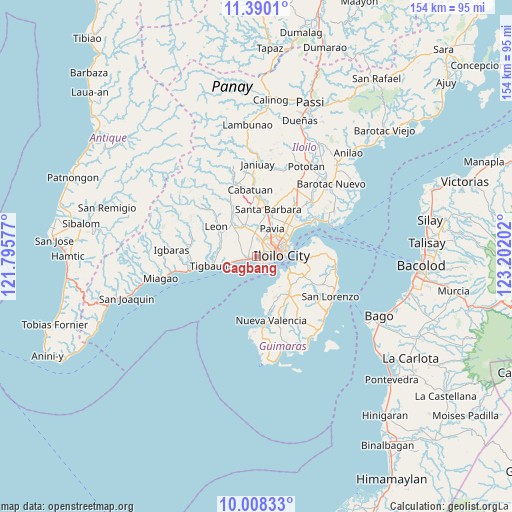
Cagbang GPS coordinates[2]
10° 42' 0" North, 122° 29' 56.004" East
| Map corner | latitude | longitude |
|---|---|---|
| Upper-left | 11.3901°, | 121.79577° |
| Center: | 10.7°, | 122.49889° |
| Lower-right: | 10.00833°, | 123.20202° |
| Map W x H: | 153.6×153.6 km | = 95.4×95.4mi |
| max Lat: | 20.78733° ⇑60.8% North |
| Cagbang: | 10.7° |
| min Lat: | ⇓39.2% South 4.65442° |
| min Long | Cagbang | max Long |
| 117.04868° | 122.49889° | 126.58417° |
| W 45.2%⇐ | ⇒54.8% E |
Elevation
Elevation of Cagbang is 5 m = 16 ft, and this is 82.9 m = 272 ft below average elevation for this country.
| Max E: |
2262 m = 7421 ft | 95.5% |
| Avg. | 87.9 m = 288 ft | |
| Cagbang | 5 m = 16 ft | |
Min E: |
-2 m = -7 ft | 4.5% |
See also: Philippines elevation on elevation.city.
Geographical zone
Cagbang is located in North Torrid zone (between Equator and Tropic of Cancer). Distance of Equator is 1189.7 km =739.2 mi to South.| Distance of | km | miles | from Cagbang |
|---|---|---|---|
| North Pole | 8817.3 | 5478.8 | to North |
| Arctic Circle | 6211.4 | 3859.6 | to North |
| Tropic Cancer | 1416.2 | 880 | to North |
| Equator | 1189.7 | 739.2 | to South |


Nearby cities:
15 places around Cagbang: (largest is in red/bold)
• Abilay
3.7 km =2.3 mi,  1°
1°
• Atabayan
9.2 km =5.7 mi,  258°
258°
• Balabag
7.1 km =4.4 mi,  354°
354°
• Buray
4.6 km =2.9 mi,  291°
291°
• Iloilo
7.2 km =4.5 mi,  92°
92°
• Jibao-an
9.3 km =5.8 mi, 0°
• Oton
2.9 km =1.8 mi,  254°
254°
• Pakiad
3.1 km =1.9 mi,  62°
62°
• Pavia
9.9 km =6.2 mi,  31°
31°
• San Jose
8.7 km =5.4 mi, 26°
• San Miguel
9.6 km =6 mi,  337°
337°
• San Nicolas
1.8 km =1.1 mi,  191°
191°
• Santa Monica
6.4 km =4 mi,  309°
309°
• Trapiche
7.5 km =4.7 mi, 256°
• Ungca
7.9 km =4.9 mi,  45°
45°
Sources, notices
• [Note1] Compared only with cities in Philippines existing in our database
• [Src1] Map data: © OpenStreetMap contributors (CC-BY-SA)
• [Src2] Other city data from geonames.org with taken over terms of usage.
• [Src3] Geographical zone / Annual Mean Temperature by Robert A. Rohde @ Wikipedia
