Iloilo geodata
Iloilo (Western Visayas) is a seat of a second-order administrative division; located in Philippines in Asia/Manila (GMT+8) time zone. With population of 387,681 people, there are 19 cities with bigger population in this country. Compared to other cities in Philippines, 60.9% of cities are located further ↑North; 53.5% of cities are located further →East and 85.4% of cities have higher elevation than Iloilo. Note1
Administrative division(s):
- Level 1: Western Visayas
- Level 2: Province of Iloilo
- Level 3: Iloilo City


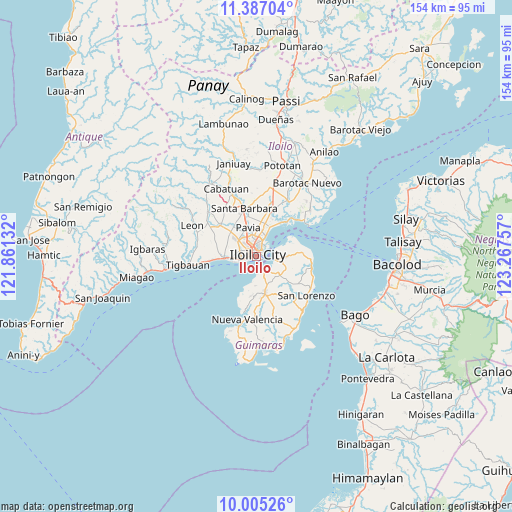
Iloilo GPS coordinates[2]
10° 41' 48.984" North, 122° 33' 51.984" East
| Map corner | latitude | longitude |
|---|---|---|
| Upper-left | 11.38704°, | 121.86132° |
| Center: | 10.69694°, | 122.56444° |
| Lower-right: | 10.00526°, | 123.26757° |
| Map W x H: | 153.6×153.6 km | = 95.4×95.4mi |
| max Lat: | 20.78733° ⇑60.9% North |
| Iloilo: | 10.69694° |
| min Lat: | ⇓39.1% South 4.65442° |
| min Long | Iloilo | max Long |
| 117.04868° | 122.56444° | 126.58417° |
| W 46.5%⇐ | ⇒53.5% E |
Elevation
Elevation of Iloilo is 8 m = 26 ft, and this is 79.9 m = 262 ft below average elevation for this country.
| Max E: |
2262 m = 7421 ft | 85.4% |
| Avg. | 87.9 m = 288 ft | |
| Iloilo | 8 m = 26 ft | |
Min E: |
-2 m = -7 ft | 14.6% |
See also: Iloilo elevation on elevation.city.
Geographical zone
Iloilo is located in North Torrid zone (between Equator and Tropic of Cancer). Distance of Equator is 1189.4 km =739.1 mi to South.| Distance of | km | miles | from Iloilo |
|---|---|---|---|
| North Pole | 8817.7 | 5479.1 | to North |
| Arctic Circle | 6211.8 | 3859.8 | to North |
| Tropic Cancer | 1416.5 | 880.2 | to North |
| Equator | 1189.4 | 739.1 | to South |


Nearby cities:
15 places around Iloilo: (largest is in red/bold)
• Abilay
8.1 km =5 mi,  299°
299°
• Aganan
10.2 km =6.3 mi,  340°
340°
• Buenavista
6.9 km =4.3 mi,  86°
86°
• Cagbang
7.2 km =4.5 mi,  272°
272°
• Jordan
5.5 km =3.4 mi,  140°
140°
• Morobuan
8 km =5 mi,  187°
187°
• Oton
9.9 km =6.2 mi, 267°
• Pakiad
4.7 km =2.9 mi,  291°
291°
• Pavia
9 km =5.6 mi,  346°
346°
• Rizal
7.7 km =4.8 mi,  101°
101°
• Salvacion
5.9 km =3.7 mi, 104°
• San Jose
8.8 km =5.5 mi, 337°
• San Nicolas
7.7 km =4.8 mi,  259°
259°
• Tigum
9.6 km =6 mi,  1°
1°
• Ungca
6.1 km =3.8 mi, 345°
Sources, notices
• [Note1] Compared only with cities in Philippines existing in our database
• [Src1] Map data: © OpenStreetMap contributors (CC-BY-SA)
• [Src2] Other city data from geonames.org with taken over terms of usage.
• [Src3] Geographical zone / Annual Mean Temperature by Robert A. Rohde @ Wikipedia
