Tutay geodata
Tutay (Central Visayas) is a populated place; located in Philippines in Asia/Manila (GMT+8) time zone. With population of 7,808 people, there are 793 cities with bigger population in this country. Compared to other cities in Philippines, 65.8% of cities are located further ↑North; 63.6% of cities are located further ←West and 65.1% of cities have higher elevation than Tutay. Note1
Administrative division(s):
- Level 1: Central Visayas
- Level 2: Province of Cebu
- Level 3: Pinamungahan


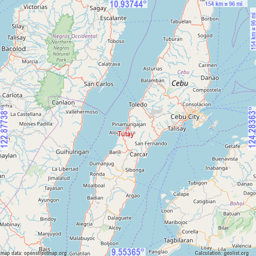
Tutay GPS coordinates[2]
10° 14' 46.68" North, 123° 34' 49.8" East
| Map corner | latitude | longitude |
|---|---|---|
| Upper-left | 10.93744°, | 122.87738° |
| Center: | 10.2463°, | 123.5805° |
| Lower-right: | 9.55365°, | 124.28363° |
| Map W x H: | 153.9×153.9 km | = 95.6×95.6mi |
| max Lat: | 20.78733° ⇑65.8% North |
| Tutay: | 10.2463° |
| min Lat: | ⇓34.2% South 4.65442° |
| min Long | Tutay | max Long |
| 117.04868° | 123.5805° | 126.58417° |
| W 63.6%⇐ | ⇒36.4% E |
Elevation
Elevation of Tutay is 14 m = 46 ft, and this is 73.9 m = 242 ft below average elevation for this country.
| Max E: |
2262 m = 7421 ft | 65.1% |
| Avg. | 87.9 m = 288 ft | |
| Tutay | 14 m = 46 ft | |
Min E: |
-2 m = -7 ft | 34.9% |
See also: Philippines elevation on elevation.city.
Geographical zone
Tutay is located in North Torrid zone (between Equator and Tropic of Cancer). Distance of Equator is 1139.3 km =707.9 mi to South.| Distance of | km | miles | from Tutay |
|---|---|---|---|
| North Pole | 8867.8 | 5510.2 | to North |
| Arctic Circle | 6261.9 | 3891 | to North |
| Tropic Cancer | 1466.6 | 911.3 | to North |
| Equator | 1139.3 | 707.9 | to South |


Nearby cities:
15 places around Tutay: (largest is in red/bold)
• Aloguinsan
4.4 km =2.7 mi,  232°
232°
• Alpaco
11.2 km =7 mi,  91°
91°
• Barili
16.5 km =10.3 mi,  207°
207°
• Bonbon
3.5 km =2.2 mi, 226°
• Buenavista
8 km =5 mi,  163°
163°
• Can-asujan
15.4 km =9.6 mi,  146°
146°
• Guadalupe
14.7 km =9.1 mi,  168°
168°
• Japitan
15.6 km =9.7 mi, 212°
• Lut-od
5.5 km =3.4 mi,  77°
77°
• Mantalongon
13.4 km =8.3 mi,  179°
179°
• Pinamungahan
2.7 km =1.7 mi,  7°
7°
• Tajao
7.6 km =4.7 mi,  2°
2°
• Toledo
15.9 km =9.9 mi,  23°
23°
• Uling
14.7 km =9.1 mi,  74°
74°
• Valencia
12.8 km =8 mi, 164°
Sources, notices
• [Note1] Compared only with cities in Philippines existing in our database
• [Src1] Map data: © OpenStreetMap contributors (CC-BY-SA)
• [Src2] Other city data from geonames.org with taken over terms of usage.
• [Src3] Geographical zone / Annual Mean Temperature by Robert A. Rohde @ Wikipedia
