Aloguinsan geodata
Aloguinsan (Central Visayas) is a seat of a third-order administrative division; located in Philippines in Asia/Manila (GMT+8) time zone. With population of 2,721 people, there are 2908 cities with bigger population in this country. Compared to other cities in Philippines, 66.1% of cities are located further ↑North; 63.1% of cities are located further ←West and 92.7% of cities have higher elevation than Aloguinsan. Note1


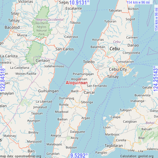
Aloguinsan GPS coordinates[2]
10° 13' 18.84" North, 123° 32' 53.88" East
| Map corner | latitude | longitude |
|---|---|---|
| Upper-left | 10.9131°, | 122.84518° |
| Center: | 10.2219°, | 123.5483° |
| Lower-right: | 9.5292°, | 124.25143° |
| Map W x H: | 153.9×153.9 km | = 95.6×95.6mi |
| max Lat: | 20.78733° ⇑66.1% North |
| Aloguinsan: | 10.2219° |
| min Lat: | ⇓33.9% South 4.65442° |
| min Long | Aloguinsan | max Long |
| 117.04868° | 123.5483° | 126.58417° |
| W 63.1%⇐ | ⇒36.9% E |
Elevation
Elevation of Aloguinsan is 6 m = 20 ft, and this is 81.9 m = 269 ft below average elevation for this country.
| Max E: |
2262 m = 7421 ft | 92.7% |
| Avg. | 87.9 m = 288 ft | |
| Aloguinsan | 6 m = 20 ft | |
Min E: |
-2 m = -7 ft | 7.3% |
See also: Philippines elevation on elevation.city.
Geographical zone
Aloguinsan is located in North Torrid zone (between Equator and Tropic of Cancer). Distance of Equator is 1136.6 km =706.3 mi to South.| Distance of | km | miles | from Aloguinsan |
|---|---|---|---|
| North Pole | 8870.5 | 5511.9 | to North |
| Arctic Circle | 6264.6 | 3892.6 | to North |
| Tropic Cancer | 1469.4 | 913 | to North |
| Equator | 1136.6 | 706.3 | to South |


Nearby cities:
15 places around Aloguinsan: (largest is in red/bold)
• Alpaco
14.9 km =9.3 mi,  80°
80°
• Barili
12.6 km =7.8 mi,  199°
199°
• Bonbon
1 km =0.6 mi,  73°
73°
• Buenavista
7.6 km =4.7 mi,  130°
130°
• Can-asujan
15.7 km =9.8 mi, 130°
• Guadalupe
13.4 km =8.3 mi,  151°
151°
• Guibodangan
13.2 km =8.2 mi,  206°
206°
• Japitan
11.5 km =7.1 mi, 205°
• Lut-od
9.7 km =6 mi, 66°
• Mantalongon
11.2 km =7 mi,  161°
161°
• Minolos
15.7 km =9.8 mi, 211°
• Pinamungahan
6.7 km =4.2 mi,  35°
35°
• Tajao
11 km =6.8 mi,  20°
20°
• Tutay
4.4 km =2.7 mi,  52°
52°
• Valencia
11.9 km =7.4 mi,  143°
143°
Sources, notices
• [Note1] Compared only with cities in Philippines existing in our database
• [Src1] Map data: © OpenStreetMap contributors (CC-BY-SA)
• [Src2] Other city data from geonames.org with taken over terms of usage.
• [Src3] Geographical zone / Annual Mean Temperature by Robert A. Rohde @ Wikipedia
