Tupsan geodata
Tupsan (Northern Mindanao) is a populated place; located in Philippines in Asia/Manila (GMT+8) time zone. With population of 2,370 people, there are 3517 cities with bigger population in this country. Compared to other cities in Philippines, 74.6% of cities are located further ↑North; 83.7% of cities are located further ←West and 60.8% of cities have higher elevation than Tupsan. Note1
Administrative division(s):
- Level 1: Northern Mindanao
- Level 2: Province of Camiguin
- Level 3: Mambajao


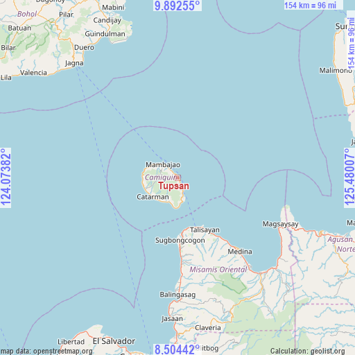
Tupsan GPS coordinates[2]
9° 11' 57.012" North, 124° 46' 36.984" East
| Map corner | latitude | longitude |
|---|---|---|
| Upper-left | 9.89255°, | 124.07382° |
| Center: | 9.19917°, | 124.77694° |
| Lower-right: | 8.50442°, | 125.48007° |
| Map W x H: | 154.3×154.3 km | = 95.9×95.9mi |
| max Lat: | 20.78733° ⇑74.6% North |
| Tupsan: | 9.19917° |
| min Lat: | ⇓25.4% South 4.65442° |
| min Long | Tupsan | max Long |
| 117.04868° | 124.77694° | 126.58417° |
| W 83.7%⇐ | ⇒16.3% E |
Elevation
Elevation of Tupsan is 16 m = 52 ft, and this is 71.9 m = 236 ft below average elevation for this country.
| Max E: |
2262 m = 7421 ft | 60.8% |
| Avg. | 87.9 m = 288 ft | |
| Tupsan | 16 m = 52 ft | |
Min E: |
-2 m = -7 ft | 39.2% |
See also: Philippines elevation on elevation.city.
Geographical zone
Tupsan is located in North Torrid zone (between Equator and Tropic of Cancer). Distance of Equator is 1022.9 km =635.6 mi to South.| Distance of | km | miles | from Tupsan |
|---|---|---|---|
| North Pole | 8984.2 | 5582.5 | to North |
| Arctic Circle | 6378.3 | 3963.3 | to North |
| Tropic Cancer | 1583.1 | 983.7 | to North |
| Equator | 1022.9 | 635.6 | to South |


Nearby cities:
15 places around Tupsan: (largest is in red/bold)
• Balingoan
23.2 km =14.4 mi,  159°
159°
• Binuangan
31.6 km =19.6 mi,  177°
177°
• Bonbon
11.5 km =7.1 mi,  204°
204°
• Catarman
13.8 km =8.6 mi,  233°
233°
• Guinisiliban
11.4 km =7.1 mi, 176°
• Inobulan
34.8 km =21.6 mi, 176°
• Kinogitan
23.8 km =14.8 mi, 175°
• Mahinog
4.7 km =2.9 mi,  165°
165°
• Mambajao
8.8 km =5.5 mi,  310°
310°
• Pandan
7 km =4.3 mi, 309°
• Sagay
11.9 km =7.4 mi,  209°
209°
• Sugbongkogon
27 km =16.8 mi, 176°
• Taboc
35.7 km =22.2 mi, 176°
• Talisayan
24.9 km =15.5 mi,  152°
152°
• Yumbing
13.8 km =8.6 mi,  288°
288°
Sources, notices
• [Note1] Compared only with cities in Philippines existing in our database
• [Src1] Map data: © OpenStreetMap contributors (CC-BY-SA)
• [Src2] Other city data from geonames.org with taken over terms of usage.
• [Src3] Geographical zone / Annual Mean Temperature by Robert A. Rohde @ Wikipedia
