Mahinog geodata
Mahinog (Northern Mindanao) is a populated place; located in Philippines in Asia/Manila (GMT+8) time zone. With population of 2,781 people, there are 2816 cities with bigger population in this country. Compared to other cities in Philippines, 74.9% of cities are located further ↑North; 84% of cities are located further ←West and 55.6% of cities have lower elevation than Mahinog. Note1
Administrative division(s):
- Level 1: Northern Mindanao
- Level 2: Province of Camiguin
- Level 3: Mahinog


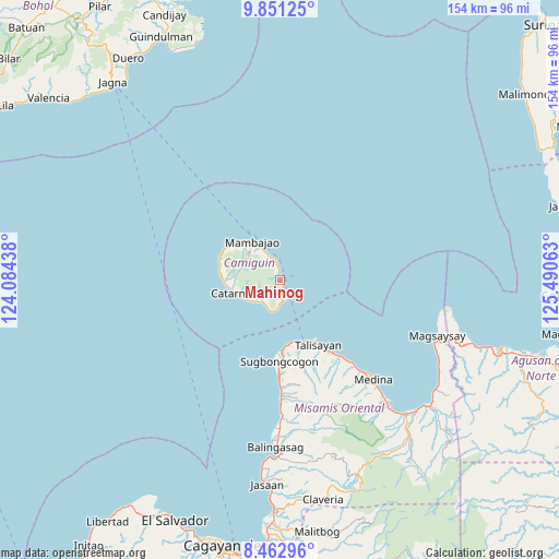
Mahinog GPS coordinates[2]
9° 9' 28.008" North, 124° 47' 15" East
| Map corner | latitude | longitude |
|---|---|---|
| Upper-left | 9.85125°, | 124.08438° |
| Center: | 9.15778°, | 124.7875° |
| Lower-right: | 8.46296°, | 125.49063° |
| Map W x H: | 154.4×154.4 km | = 95.9×95.9mi |
| max Lat: | 20.78733° ⇑74.9% North |
| Mahinog: | 9.15778° |
| min Lat: | ⇓25.1% South 4.65442° |
| min Long | Mahinog | max Long |
| 117.04868° | 124.7875° | 126.58417° |
| W 84%⇐ | ⇒16% E |
Elevation
Elevation of Mahinog is 28 m = 92 ft, and this is 59.9 m = 197 ft below average elevation for this country.
| Max E: |
2262 m = 7421 ft | 44.4% |
| Avg. | 87.9 m = 288 ft | |
| Mahinog | 28 m = 92 ft | |
Min E: |
-2 m = -7 ft | 55.6% |
See also: Philippines elevation on elevation.city.
Geographical zone
Mahinog is located in North Torrid zone (between Equator and Tropic of Cancer). Distance of Equator is 1018.2 km =632.7 mi to South.| Distance of | km | miles | from Mahinog |
|---|---|---|---|
| North Pole | 8988.8 | 5585.4 | to North |
| Arctic Circle | 6382.9 | 3966.1 | to North |
| Tropic Cancer | 1587.7 | 986.6 | to North |
| Equator | 1018.2 | 632.7 | to South |


Nearby cities:
15 places around Mahinog: (largest is in red/bold)
• Balingoan
18.5 km =11.5 mi,  157°
157°
• Binuangan
27 km =16.8 mi,  179°
179°
• Bonbon
8.3 km =5.2 mi,  225°
225°
• Catarman
12.8 km =8 mi,  253°
253°
• Guinisiliban
6.8 km =4.2 mi, 184°
• Inobulan
30.2 km =18.8 mi, 178°
• Kinogitan
19.2 km =11.9 mi, 178°
• Mambajao
13 km =8.1 mi,  322°
322°
• Pandan
11.1 km =6.9 mi, 323°
• Sagay
9 km =5.6 mi, 230°
• Sugbongkogon
22.3 km =13.9 mi, 178°
• Taboc
31.1 km =19.3 mi, 177°
• Talisayan
20.3 km =12.6 mi,  149°
149°
• Tupsan
4.7 km =2.9 mi,  345°
345°
• Yumbing
16.9 km =10.5 mi,  302°
302°
Sources, notices
• [Note1] Compared only with cities in Philippines existing in our database
• [Src1] Map data: © OpenStreetMap contributors (CC-BY-SA)
• [Src2] Other city data from geonames.org with taken over terms of usage.
• [Src3] Geographical zone / Annual Mean Temperature by Robert A. Rohde @ Wikipedia
