Guinisiliban geodata
Guinisiliban (Northern Mindanao) is a populated place; located in Philippines in Asia/Manila (GMT+8) time zone. With population of 2,074 people, there are 4113 cities with bigger population in this country. Compared to other cities in Philippines, 75.3% of cities are located further ↑North; 83.8% of cities are located further ←West and 59.5% of cities have lower elevation than Guinisiliban. Note1
Administrative division(s):
- Level 1: Northern Mindanao
- Level 2: Province of Camiguin
- Level 3: Guinsiliban


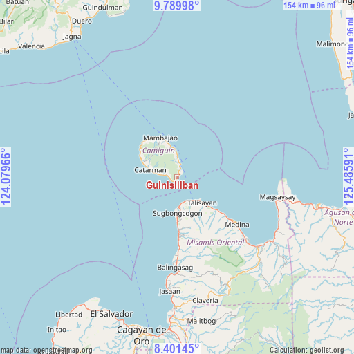
Guinisiliban GPS coordinates[2]
9° 5' 47.004" North, 124° 46' 58.008" East
| Map corner | latitude | longitude |
|---|---|---|
| Upper-left | 9.78998°, | 124.07966° |
| Center: | 9.09639°, | 124.78278° |
| Lower-right: | 8.40145°, | 125.48591° |
| Map W x H: | 154.4×154.4 km | = 95.9×95.9mi |
| max Lat: | 20.78733° ⇑75.3% North |
| Guinisiliban: | 9.09639° |
| min Lat: | ⇓24.7% South 4.65442° |
| min Long | Guinisiliban | max Long |
| 117.04868° | 124.78278° | 126.58417° |
| W 83.8%⇐ | ⇒16.2% E |
Elevation
Elevation of Guinisiliban is 33 m = 108 ft, and this is 54.9 m = 180 ft below average elevation for this country.
| Max E: |
2262 m = 7421 ft | 40.5% |
| Avg. | 87.9 m = 288 ft | |
| Guinisiliban | 33 m = 108 ft | |
Min E: |
-2 m = -7 ft | 59.5% |
See also: Philippines elevation on elevation.city.
Geographical zone
Guinisiliban is located in North Torrid zone (between Equator and Tropic of Cancer). Distance of Equator is 1011.4 km =628.5 mi to South.| Distance of | km | miles | from Guinisiliban |
|---|---|---|---|
| North Pole | 8995.6 | 5589.6 | to North |
| Arctic Circle | 6389.8 | 3970.4 | to North |
| Tropic Cancer | 1594.5 | 990.8 | to North |
| Equator | 1011.4 | 628.5 | to South |


Nearby cities:
15 places around Guinisiliban: (largest is in red/bold)
• Balingoan
12.8 km =8 mi,  143°
143°
• Binuangan
20.1 km =12.5 mi,  178°
178°
• Bonbon
5.5 km =3.4 mi,  280°
280°
• Catarman
12.2 km =7.6 mi,  285°
285°
• Inobulan
23.4 km =14.5 mi, 176°
• Kinogitan
12.4 km =7.7 mi,  174°
174°
• Mahinog
6.8 km =4.2 mi,  4°
4°
• Mambajao
18.6 km =11.6 mi,  336°
336°
• Pandan
16.9 km =10.5 mi, 339°
• Sagay
6.5 km =4 mi, 279°
• Sugbongkogon
15.5 km =9.6 mi, 176°
• Taboc
24.3 km =15.1 mi, 176°
• Talisayan
15.2 km =9.4 mi,  134°
134°
• Tupsan
11.4 km =7.1 mi,  356°
356°
• Yumbing
21 km =13 mi,  319°
319°
Sources, notices
• [Note1] Compared only with cities in Philippines existing in our database
• [Src1] Map data: © OpenStreetMap contributors (CC-BY-SA)
• [Src2] Other city data from geonames.org with taken over terms of usage.
• [Src3] Geographical zone / Annual Mean Temperature by Robert A. Rohde @ Wikipedia
