Pandan geodata
Pandan (Northern Mindanao) is a populated place; located in Philippines in Asia/Manila (GMT+8) time zone. With population of 2,332 people, there are 3603 cities with bigger population in this country. Compared to other cities in Philippines, 74.4% of cities are located further ↑North; 82.8% of cities are located further ←West and 68% of cities have lower elevation than Pandan. Note1
Administrative division(s):
- Level 1: Northern Mindanao
- Level 2: Province of Camiguin
- Level 3: Mambajao


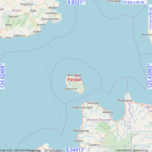
Pandan GPS coordinates[2]
9° 14' 19.68" North, 124° 43' 40.08" East
| Map corner | latitude | longitude |
|---|---|---|
| Upper-left | 9.9321°, | 124.02468° |
| Center: | 9.2388°, | 124.7278° |
| Lower-right: | 8.54413°, | 125.43093° |
| Map W x H: | 154.3×154.3 km | = 95.9×95.9mi |
| max Lat: | 20.78733° ⇑74.4% North |
| Pandan: | 9.2388° |
| min Lat: | ⇓25.6% South 4.65442° |
| min Long | Pandan | max Long |
| 117.04868° | 124.7278° | 126.58417° |
| W 82.8%⇐ | ⇒17.2% E |
Elevation
Elevation of Pandan is 48 m = 157 ft, and this is 39.9 m = 131 ft below average elevation for this country.
| Max E: |
2262 m = 7421 ft | 32% |
| Avg. | 87.9 m = 288 ft | |
| Pandan | 48 m = 157 ft | |
Min E: |
-2 m = -7 ft | 68% |
See also: Philippines elevation on elevation.city.
Geographical zone
Pandan is located in North Torrid zone (between Equator and Tropic of Cancer). Distance of Equator is 1027.3 km =638.3 mi to South.| Distance of | km | miles | from Pandan |
|---|---|---|---|
| North Pole | 8979.8 | 5579.8 | to North |
| Arctic Circle | 6373.9 | 3960.6 | to North |
| Tropic Cancer | 1578.7 | 981 | to North |
| Equator | 1027.3 | 638.3 | to South |


Nearby cities:
15 places around Pandan: (largest is in red/bold)
• Balingoan
29.5 km =18.3 mi,  152°
152°
• Binuangan
36.6 km =22.7 mi,  169°
169°
• Bonbon
14.9 km =9.3 mi,  177°
177°
• Catarman
13.8 km =8.6 mi,  204°
204°
• Guinisiliban
16.9 km =10.5 mi,  159°
159°
• Inobulan
39.9 km =24.8 mi, 169°
• Kinogitan
29 km =18 mi, 165°
• Mahinog
11.1 km =6.9 mi,  143°
143°
• Mambajao
1.9 km =1.2 mi,  313°
313°
• Sagay
14.8 km =9.2 mi, 181°
• Sugbongkogon
32.1 km =19.9 mi, 167°
• Taboc
40.8 km =25.4 mi, 169°
• Talisayan
31.4 km =19.5 mi, 147°
• Tupsan
7 km =4.3 mi,  129°
129°
• Yumbing
7.7 km =4.8 mi,  270°
270°
Sources, notices
• [Note1] Compared only with cities in Philippines existing in our database
• [Src1] Map data: © OpenStreetMap contributors (CC-BY-SA)
• [Src2] Other city data from geonames.org with taken over terms of usage.
• [Src3] Geographical zone / Annual Mean Temperature by Robert A. Rohde @ Wikipedia
