Tuhian geodata
Tuhian (Calabarzon) is a populated place; located in Philippines in Asia/Manila (GMT+8) time zone. With population of 2,646 people, there are 3032 cities with bigger population in this country. Compared to other cities in Philippines, 63.6% of cities are located further ↓South; 57.9% of cities are located further →East and 64.7% of cities have lower elevation than Tuhian. Note1


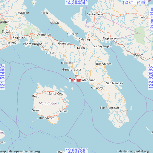
Tuhian GPS coordinates[2]
13° 37' 19.92" North, 122° 13' 4.08" East
| Map corner | latitude | longitude |
|---|---|---|
| Upper-left | 14.30454°, | 121.51468° |
| Center: | 13.6222°, | 122.2178° |
| Lower-right: | 12.93788°, | 122.92093° |
| Map W x H: | 152×152 km | = 94.4×94.4mi |
| max Lat: | 20.78733° ⇑36.4% North |
| Tuhian: | 13.6222° |
| min Lat: | ⇓63.6% South 4.65442° |
| min Long | Tuhian | max Long |
| 117.04868° | 122.2178° | 126.58417° |
| W 42.1%⇐ | ⇒57.9% E |
Elevation
Elevation of Tuhian is 41 m = 135 ft, and this is 46.9 m = 154 ft below average elevation for this country.
| Max E: |
2262 m = 7421 ft | 35.3% |
| Avg. | 87.9 m = 288 ft | |
| Tuhian | 41 m = 135 ft | |
Min E: |
-2 m = -7 ft | 64.7% |
See also: Philippines elevation on elevation.city.
Geographical zone
Tuhian is located in North Torrid zone (between Equator and Tropic of Cancer). Distance of this Northern Tropic circle is 1091.3 km =678.1 mi to North.| Distance of | km | miles | from Tuhian |
|---|---|---|---|
| North Pole | 8492.4 | 5276.9 | to North |
| Arctic Circle | 5886.5 | 3657.7 | to North |
| Tropic Cancer | 1091.3 | 678.1 | to North |
| Equator | 1514.6 | 941.1 | to South |


Nearby cities:
15 places around Tuhian: (largest is in red/bold)
• Bagupaye
19.7 km =12.2 mi,  108°
108°
• Buyabod
24.9 km =15.5 mi,  225°
225°
• Cambuga
25.1 km =15.6 mi,  91°
91°
• Catanauan
11.7 km =7.3 mi, 106°
• General Luna
8.8 km =5.5 mi,  324°
324°
• Macalelon
16.3 km =10.1 mi,  328°
328°
• Madulao
14.6 km =9.1 mi, 114°
• Mulanay
23 km =14.3 mi,  118°
118°
• Pitogo
22.6 km =14 mi, 322°
• San Francisco
20.2 km =12.6 mi,  21°
21°
• San Isidro
2.9 km =1.8 mi,  67°
67°
• Santa Cruz
26.2 km =16.3 mi, 231°
• Santa Rosa
18.6 km =11.6 mi, 112°
• Tagbacan Ibaba
16.4 km =10.2 mi,  97°
97°
• Tayabas Ibaba
6.9 km =4.3 mi, 90°
Sources, notices
• [Note1] Compared only with cities in Philippines existing in our database
• [Src1] Map data: © OpenStreetMap contributors (CC-BY-SA)
• [Src2] Other city data from geonames.org with taken over terms of usage.
• [Src3] Geographical zone / Annual Mean Temperature by Robert A. Rohde @ Wikipedia
