Santa Cruz geodata
Santa Cruz (Mimaropa) is a seat of a third-order administrative division; located in Philippines in Asia/Manila (GMT+8) time zone. With population of 9,863 people, there are 617 cities with bigger population in this country. Compared to other cities in Philippines, 62% of cities are located further ↓South; 59.8% of cities are located further →East and 68.9% of cities have lower elevation than Santa Cruz. Note1


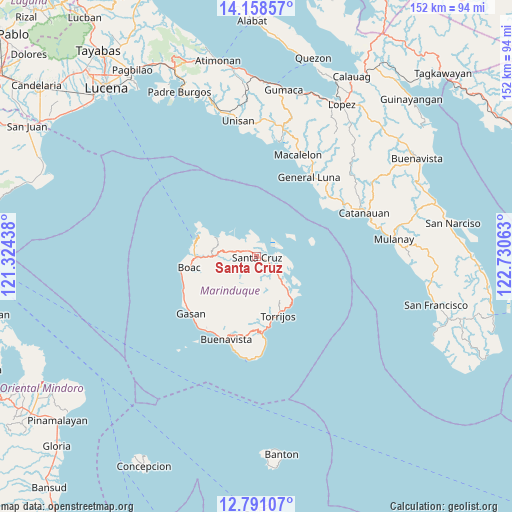
Santa Cruz GPS coordinates[2]
13° 28' 32.88" North, 122° 1' 39" East
| Map corner | latitude | longitude |
|---|---|---|
| Upper-left | 14.15857°, | 121.32438° |
| Center: | 13.4758°, | 122.0275° |
| Lower-right: | 12.79107°, | 122.73063° |
| Map W x H: | 152.1×152.1 km | = 94.5×94.5mi |
| max Lat: | 20.78733° ⇑38% North |
| Santa Cruz: | 13.4758° |
| min Lat: | ⇓62% South 4.65442° |
| min Long | Santa Cruz | max Long |
| 117.04868° | 122.0275° | 126.58417° |
| W 40.2%⇐ | ⇒59.8% E |
Elevation
Elevation of Santa Cruz is 50 m = 164 ft, and this is 37.9 m = 124 ft below average elevation for this country.
| Max E: |
2262 m = 7421 ft | 31.1% |
| Avg. | 87.9 m = 288 ft | |
| Santa Cruz | 50 m = 164 ft | |
Min E: |
-2 m = -7 ft | 68.9% |
See also: Philippines elevation on elevation.city.
Geographical zone
Santa Cruz is located in North Torrid zone (between Equator and Tropic of Cancer). Distance of this Northern Tropic circle is 1107.6 km =688.2 mi to North.| Distance of | km | miles | from Santa Cruz |
|---|---|---|---|
| North Pole | 8508.7 | 5287.1 | to North |
| Arctic Circle | 5902.8 | 3667.8 | to North |
| Tropic Cancer | 1107.6 | 688.2 | to North |
| Equator | 1498.4 | 931.1 | to South |


Nearby cities:
15 places around Santa Cruz: (largest is in red/bold)
• Balanacan
18.3 km =11.4 mi,  288°
288°
• Barangay of Poblacion
18.5 km =11.5 mi,  162°
162°
• Bintacay
16.5 km =10.3 mi,  278°
278°
• Boac
20.5 km =12.7 mi,  260°
260°
• Buyabod
2.9 km =1.8 mi,  110°
110°
• Daykitin
26.1 km =16.2 mi,  208°
208°
• Gasan
25.8 km =16 mi,  229°
229°
• Ipil
6.3 km =3.9 mi,  311°
311°
• Laylay
22.8 km =14.2 mi, 259°
• Malibago
22 km =13.7 mi,  181°
181°
• Masiga
25.1 km =15.6 mi,  239°
239°
• Mogpog
18 km =11.2 mi,  269°
269°
• Tigui
23.1 km =14.4 mi, 176°
• Tiguion
23.9 km =14.9 mi, 228°
• Torrijos
18.6 km =11.6 mi, 161°
Sources, notices
• [Note1] Compared only with cities in Philippines existing in our database
• [Src1] Map data: © OpenStreetMap contributors (CC-BY-SA)
• [Src2] Other city data from geonames.org with taken over terms of usage.
• [Src3] Geographical zone / Annual Mean Temperature by Robert A. Rohde @ Wikipedia
