Buyabod geodata
Buyabod (Mimaropa) is a populated place; located in Philippines in Asia/Manila (GMT+8) time zone. With population of 2,991 people, there are 2534 cities with bigger population in this country. Compared to other cities in Philippines, 61.9% of cities are located further ↓South; 59.5% of cities are located further →East and 73.2% of cities have higher elevation than Buyabod. Note1


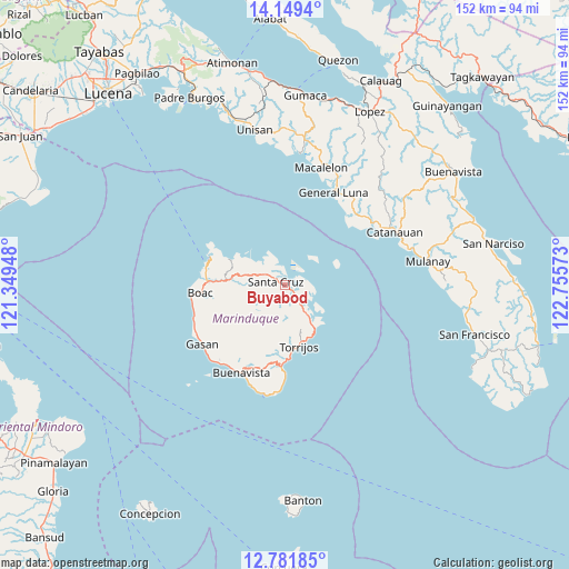
Buyabod GPS coordinates[2]
13° 27' 59.76" North, 122° 3' 9.36" East
| Map corner | latitude | longitude |
|---|---|---|
| Upper-left | 14.1494°, | 121.34948° |
| Center: | 13.4666°, | 122.0526° |
| Lower-right: | 12.78185°, | 122.75573° |
| Map W x H: | 152.1×152.1 km | = 94.5×94.5mi |
| max Lat: | 20.78733° ⇑38.1% North |
| Buyabod: | 13.4666° |
| min Lat: | ⇓61.9% South 4.65442° |
| min Long | Buyabod | max Long |
| 117.04868° | 122.0526° | 126.58417° |
| W 40.5%⇐ | ⇒59.5% E |
Elevation
Elevation of Buyabod is 11 m = 36 ft, and this is 76.9 m = 252 ft below average elevation for this country.
| Max E: |
2262 m = 7421 ft | 73.2% |
| Avg. | 87.9 m = 288 ft | |
| Buyabod | 11 m = 36 ft | |
Min E: |
-2 m = -7 ft | 26.8% |
See also: Philippines elevation on elevation.city.
Geographical zone
Buyabod is located in North Torrid zone (between Equator and Tropic of Cancer). Distance of this Northern Tropic circle is 1108.6 km =688.9 mi to North.| Distance of | km | miles | from Buyabod |
|---|---|---|---|
| North Pole | 8509.7 | 5287.7 | to North |
| Arctic Circle | 5903.8 | 3668.5 | to North |
| Tropic Cancer | 1108.6 | 688.9 | to North |
| Equator | 1497.3 | 930.4 | to South |


Nearby cities:
15 places around Buyabod: (largest is in red/bold)
• Balanacan
21.2 km =13.2 mi,  289°
289°
• Barangay of Poblacion
16.8 km =10.4 mi,  170°
170°
• Bintacay
19.3 km =12 mi,  280°
280°
• Boac
23.1 km =14.4 mi,  264°
264°
• Buenavista
26.4 km =16.4 mi,  207°
207°
• Caigangan
26.5 km =16.5 mi, 209°
• Ipil
9 km =5.6 mi,  304°
304°
• Laylay
25.3 km =15.7 mi, 263°
• Malibago
21.2 km =13.2 mi,  188°
188°
• Mogpog
20.7 km =12.9 mi,  272°
272°
• Santa Cruz
2.9 km =1.8 mi, 290°
• Tigui
22.1 km =13.7 mi,  183°
183°
• Tiguion
25.4 km =15.8 mi,  234°
234°
• Torrijos
17 km =10.6 mi, 169°
• Tuhian
24.9 km =15.5 mi,  45°
45°
Sources, notices
• [Note1] Compared only with cities in Philippines existing in our database
• [Src1] Map data: © OpenStreetMap contributors (CC-BY-SA)
• [Src2] Other city data from geonames.org with taken over terms of usage.
• [Src3] Geographical zone / Annual Mean Temperature by Robert A. Rohde @ Wikipedia
