Tudela geodata
Tudela (Central Visayas) is a seat of a third-order administrative division; located in Philippines in Asia/Manila (GMT+8) time zone. In our database, there are 4166 cities with bigger population. Compared to other cities in Philippines, 61.7% of cities are located further ↑North; 78.5% of cities are located further ←West and 73.2% of cities have higher elevation than Tudela. Note1


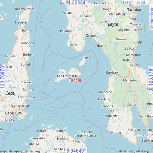
Tudela GPS coordinates[2]
10° 38' 17.88" North, 124° 28' 22.332" East
| Map corner | latitude | longitude |
|---|---|---|
| Upper-left | 11.32854°, | 123.76975° |
| Center: | 10.6383°, | 124.47287° |
| Lower-right: | 9.94649°, | 125.176° |
| Map W x H: | 153.7×153.7 km | = 95.5×95.5mi |
| max Lat: | 20.78733° ⇑61.7% North |
| Tudela: | 10.6383° |
| min Lat: | ⇓38.3% South 4.65442° |
| min Long | Tudela | max Long |
| 117.04868° | 124.47287° | 126.58417° |
| W 78.5%⇐ | ⇒21.5% E |
Elevation
Elevation of Tudela is 11 m = 36 ft, and this is 76.9 m = 252 ft below average elevation for this country.
| Max E: |
2262 m = 7421 ft | 73.2% |
| Avg. | 87.9 m = 288 ft | |
| Tudela | 11 m = 36 ft | |
Min E: |
-2 m = -7 ft | 26.8% |
See also: Philippines elevation on elevation.city.
Geographical zone
Tudela is located in North Torrid zone (between Equator and Tropic of Cancer). Distance of Equator is 1182.9 km =735 mi to South.| Distance of | km | miles | from Tudela |
|---|---|---|---|
| North Pole | 8824.2 | 5483.1 | to North |
| Arctic Circle | 6218.3 | 3863.9 | to North |
| Tropic Cancer | 1423.1 | 884.3 | to North |
| Equator | 1182.9 | 735 | to South |


Nearby cities:
15 places around Tudela: (largest is in red/bold)
• Bilwang
27.3 km =17 mi,  358°
358°
• Consuelo
18.8 km =11.7 mi,  268°
268°
• Esperanza
9.6 km =6 mi,  318°
318°
• Esperanza
18.6 km =11.6 mi,  291°
291°
• Himensulan
21.4 km =13.3 mi,  257°
257°
• Libertad
31.1 km =19.3 mi, 355°
• Matlang
28.1 km =17.5 mi, 356°
• Mercedes
8.4 km =5.2 mi, 293°
• Merida
31 km =19.3 mi,  13°
13°
• Pilar
21.3 km =13.2 mi,  28°
28°
• Poro
7.1 km =4.4 mi, 261°
• San Francisco
10 km =6.2 mi, 274°
• Santa Cruz
14.7 km =9.1 mi,  275°
275°
• Santiago
19 km =11.8 mi,  253°
253°
• Union
16.5 km =10.3 mi, 282°
Sources, notices
• [Note1] Compared only with cities in Philippines existing in our database
• [Src1] Map data: © OpenStreetMap contributors (CC-BY-SA)
• [Src2] Other city data from geonames.org with taken over terms of usage.
• [Src3] Geographical zone / Annual Mean Temperature by Robert A. Rohde @ Wikipedia
